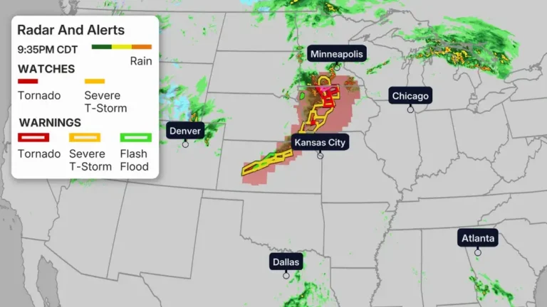
Nebraska faced a dangerous round of severe weather Sunday evening as tornado warnings, severe thunderstorm alerts and damaging storms moved across Omaha and nearby communities. The fast-moving system caused power outages, delayed flights at Omaha’s Eppley Airfield and triggered emergency warnings across eastern Nebraska and western Iowa.
Multiple tornado warnings were issued during the evening, including alerts for parts of Douglas, Sarpy, Cass, Lancaster, Otoe, Saunders, Harrison, Pottawattamie and Washington counties. The warnings came as rotating thunderstorms strengthened and moved through populated areas, prompting residents to seek shelter and monitor official alerts.
Local weather coverage reported that more than 3,500 customers lost power in the Omaha metro area as strong thunderstorms pushed through the region. Forecasters also warned of large hail, destructive wind gusts and the potential for tornadoes as the storm line expanded eastward.
Flights delayed at Omaha’s Eppley Airfield
The severe weather also disrupted travel at Omaha’s Eppley Airfield. Flights were delayed as thunderstorms and tornado warnings affected parts of Nebraska and Iowa. Airport operations can slow quickly during severe weather because lightning, strong wind gusts and low visibility create dangerous conditions for aircraft movement and ground crews.
Travelers were advised to check airline schedules and airport updates before leaving for the airport. The storms created widespread concern across the Omaha metro area as warnings continued into the night.
One of the most serious warnings came around 8:15 p.m. local time, when a tornado warning was issued for Douglas, Sarpy and Pottawattamie counties, including parts of the Omaha metro. Residents in affected areas were urged to move immediately to the lowest floor of a sturdy building, preferably underground.
Tornado warnings spread across Nebraska
The storm outbreak intensified during the late afternoon and evening hours. Earlier in the day, the National Weather Service issued a tornado watch covering much of eastern Nebraska and western Iowa until 11 p.m. Meteorologists warned that the atmosphere could support tornadoes, large hail and destructive straight-line winds.
Several severe thunderstorm warnings mentioned hail as large as golf balls and wind gusts above 70 mph. In some areas, forecasters warned of potentially destructive storms capable of producing baseball-sized hail and winds near 80 mph.
Warnings were issued in waves as storms tracked across Platte, Colfax, Stanton, Madison, Lancaster, Saunders, Gage, Jefferson and surrounding counties before reaching the Omaha metro area. Local television coverage also reported at least one confirmed tornado in south-central Nebraska, while separate reports highlighted tornado activity near St. Libory.
The severe weather setup developed as warm, humid air collided with stronger winds higher in the atmosphere, creating conditions favorable for rotating supercell thunderstorms. These storms can produce tornadoes, large hail and damaging wind events.
For official weather alerts and radar updates, residents were encouraged to monitor the National Weather Service Omaha office. Swikblog also explains the difference between watches and warnings here: Tornado Watch vs Warning Explained.
Make Swikblog your go-to source on Google for reliable updates, smart insights, and daily trends.