A widespread Flood Watch has been issued across New York, and this is shaping up to be more than just another rainy day. From Buffalo to Syracuse and beyond, forecasters are warning of a dangerous mix of heavy rain, severe thunderstorms and even a small tornado risk as a powerful weather system moves through the region.
The watch is in effect from Tuesday morning through Wednesday evening, covering large parts of western, central and eastern New York. Areas impacted include Erie, Niagara, Monroe, Wayne, Ontario, Livingston, Genesee, Wyoming, Jefferson, Lewis, Oswego, Oneida, Herkimer and Hamilton counties, along with portions of the Southern Tier and the western Adirondacks. Major cities such as Buffalo, Rochester, Syracuse, Watertown and Utica all fall within the risk zone.
This is not a one-time burst of rain. Forecasters are tracking multiple rounds of showers and thunderstorms expected to move across the state through Tuesday night. Some of these storms could turn severe, especially in Western New York, where damaging wind gusts near 60 mph are possible. Large hail may also develop, and there is a chance of an isolated tornado later in the day.
Buffalo is expected to see heavy rain early Tuesday morning, with temperatures near 60 degrees. Conditions may briefly ease before another round of thunderstorms builds in the afternoon, when the risk of severe weather increases. By Wednesday morning, showers will linger with cooler temperatures around 40 degrees, followed by cloudy skies through the afternoon.
Looking ahead, the unsettled pattern does not clear quickly. Thursday brings mostly cloudy skies in the morning and showers returning by the afternoon with temperatures near 60. Friday remains damp with morning showers and mostly cloudy conditions later in the day, while Saturday continues the trend with more clouds and additional rain chances.
Why flooding is a serious concern right now
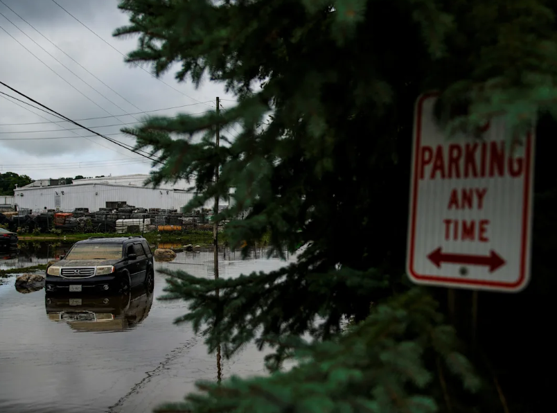
The biggest threat with this system is not just the storms, but the amount of water expected to fall in a short period of time. Several inches of rainfall could accumulate over two to three days. That alone would raise concerns, but this system is being intensified by melting snowpack in higher elevations, especially across areas like the Tug Hill Plateau and the Adirondacks.
When rainfall combines with snowmelt, water levels can rise quickly. Rivers, creeks and streams may approach or even exceed their banks, particularly in areas where the heaviest rain persists. The Black River basin is one of the regions being closely monitored due to its sensitivity to rapid water level changes.
Urban areas are also at risk. Poor drainage systems can become overwhelmed, leading to water pooling on streets and in low-lying neighborhoods. Even moderate rainfall rates can cause localized flooding when repeated rounds of storms hit the same location.
Officials warn that flooding could impact roads, basements and flood-prone properties. In some cases, water may cover roadways, creating dangerous travel conditions, especially during periods of reduced visibility from heavy rain and thunderstorms.
What residents should expect and do next
While a Flood Watch does not mean flooding is already happening, it signals that conditions are favorable and could worsen quickly. Residents across New York are being urged to stay alert as forecasts update throughout the day and night.
The timing of the storms adds another layer of concern. Heavy rain during the morning hours may saturate the ground, making it easier for additional rainfall later in the day to run off quickly and cause flooding. Afternoon and evening storms could bring stronger impacts, including severe weather.
People living in flood-prone areas should be prepared for rapid changes. Monitoring local alerts, avoiding unnecessary travel during heavy rain, and never driving through water-covered roads are key safety steps. Even a small amount of moving water can be more dangerous than it appears.
For updated safety guidance, residents can refer to official flood preparedness recommendations, which outline how to respond if water levels begin to rise.
This system brings a combination of risks that do not often line up at the same time—heavy rain, repeated storm activity, melting snow and severe weather potential. That combination is why forecasters are urging caution across such a large portion of the state.
As New York moves through the next 48 hours, the situation will depend on where the heaviest rain bands set up and how quickly waterways respond. For now, the message is clear: stay alert, stay updated, and take the Flood Watch seriously as conditions continue to evolve.
You may also like: Chinese Satellite Maker GalaxySpace Starts IPO Process as Starlink Race Intensifies
Make Swikblog your go-to source on Google for reliable updates, smart insights, and daily trends.