By Anne Watson
April may be underway, but winter is far from finished across parts of the United States. In a surprising turn for the season, meteorologists have issued an ice storm warning alongside fresh winter storm alerts as a powerful system targets the Midwest and Great Lakes just days before Easter.
Forecasters say this is not a minor late-season chill. A combination of 6 to 12 inches of snow, 40 mph wind gusts, and widespread icing is expected to create dangerous travel conditions from Wednesday through Friday, with another round of disruptive weather possible over the Easter weekend.
The system is set to impact a wide stretch of the country, including central South Dakota, much of Minnesota, northern Wisconsin, and Michigan’s Upper Peninsula. Additional impacts are expected to extend into Iowa, the broader Great Lakes region, and even northern New England as the pattern evolves.
Snow, ice and falling temperatures set the stage for hazardous travel
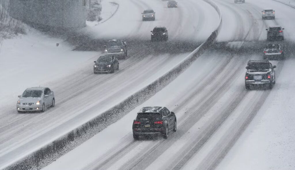
What makes this storm particularly concerning is how quickly conditions are expected to change. After a brief spell of unseasonably warm weather earlier in the week, temperatures are forecast to drop sharply as the storm system moves in. That sudden shift will allow rain to turn into snow and ice within hours, catching many people off guard.
According to forecasters, snowfall will begin Wednesday afternoon and intensify through Thursday night. In many northern areas, totals could reach between 6 and 12 inches, with the heaviest accumulation focused across Minnesota and surrounding regions. The snow is expected to be wet and heavy, meaning it will cling to surfaces rather than blowing away easily.
This type of snow brings added risk. When combined with strong winds up to 40 mph, it can weigh down trees and power lines, increasing the chances of power outages and blocked roads. Visibility may also drop significantly during periods of heavier snowfall, especially in open areas where wind can blow snow across highways.
Travel is expected to be one of the biggest concerns. Roads across affected states could quickly become slick and unpredictable, particularly during the evening and overnight hours when temperatures fall further. Even major highways may see reduced traction and slower movement, while rural and secondary roads could become difficult to navigate.
The situation becomes even more complicated in regions facing icing rather than pure snowfall. Areas closer to the rain-snow line, including parts of Michigan, Wisconsin, and the Great Lakes, are bracing for freezing rain that could coat roads, vehicles, and infrastructure with a thin but dangerous layer of ice.
More details on the evolving system can be tracked via The Weather Channel’s storm updates, where meteorologists continue to monitor how the storm track may shift.
Easter weekend faces fresh disruption as another storm looms
As if the midweek storm was not enough, forecasters are already watching another system expected to arrive over the Easter weekend. This second round could bring additional snow and ice across parts of Minnesota, South Dakota, Iowa, Wisconsin, northern Michigan, and even far northern Maine.
The biggest concern with this follow-up system is the potential for a more widespread ice storm event. Meteorologists warn that parts of the Great Lakes and northern New England could see icing significant enough to disrupt power supply and travel once again.
At the same time, areas farther south may see a different side of the same storm system, including heavy rain and even thunderstorms. The exact track will determine which regions experience snow and ice versus rain, adding a layer of uncertainty that keeps forecasts under close watch.
The Easter timing adds another level of impact. Holiday weekends typically bring increased travel across highways and airports, and storms of this scale can create ripple effects beyond the hardest-hit areas. Delays, cancellations, and slower road travel could affect thousands of people planning to visit family or attend events.
For many, the biggest surprise is simply the timing. April is usually associated with warming temperatures and the arrival of spring, not winter storm warnings and ice threats. Yet this system is a clear reminder that seasonal transitions do not always follow a predictable path.
Forecasters say this could be one of the final significant winter events before a more consistent warming trend takes hold later in the season. Still, for now, the message remains clear: conditions can deteriorate quickly, and preparation is key.
With an ice storm warning in place, heavy snowfall totals, and strong winds all combining at once, this late-season storm is shaping up to be one of the most impactful weather events in recent weeks—arriving just as many were ready to leave winter behind.
Make Swikblog your go-to source on Google for reliable updates, smart insights, and daily trends.