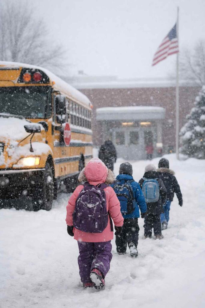
A powerful late-season winter storm slammed the Upper Midwest over the weekend, dumping heavy snow across Minnesota and neighboring states and forcing widespread school closures Monday. The storm disrupted travel, triggered blizzard warnings and buried parts of the region under more than a foot of snow, with the Twin Cities among the areas feeling the impact.
Because of the dangerous conditions, St. Paul Public Schools canceled all classes Monday, while Minneapolis Public Schools closed in-person learning for pre-K through fifth grade. Middle and high school students in Minneapolis shifted to remote learning as the storm continued affecting travel and road safety.
St. Paul Schools Cancel Classes Completely
St. Paul Public Schools announced a full closure Monday due to hazardous weather conditions caused by the weekend snowstorm. Officials said the closure would not include an e-learning day, meaning students were given a traditional snow day.
The district also confirmed that Discovery Club and Adult Basic Education programs were closed. Most after-school activities and athletic events were canceled as well, although varsity sports could continue depending on decisions made by individual school administrators.
School officials said safety concerns for students and staff traveling in the storm played a major role in the decision.
Minneapolis Declares Severe Weather Day
Minneapolis Public Schools took a slightly different approach but still canceled in-person classes for younger students. The district declared Monday a severe weather day, closing schools for pre-kindergarten through fifth grade. Middle and high school students were instructed to continue learning through e-learning platforms.
The split approach reflects a growing trend among districts that use remote learning options to minimize lost instruction time during major weather events.
Heavy Snow Blankets Minnesota and Midwest
The storm was part of a massive winter weather system that stretched across much of the Upper Midwest and Great Lakes region. According to weather reports, large areas from southeastern Minnesota to northern Michigan saw extremely heavy snowfall.
Some locations recorded more than 20 inches of snow, creating blizzard conditions and dangerous travel throughout the region.
Among the hardest-hit locations:
- Herman, Michigan: 36 inches of snow
- Mountain, Wisconsin: 34 inches
- Minneapolis–St. Paul Airport: about 8.8 inches
- Multiple communities across Wisconsin and Michigan reported over 20 inches
In Wisconsin, the storm shattered long-standing snowfall records. Wausau recorded 23.4 inches in a single day, the snowiest day in the city’s 130-year history. Green Bay also experienced one of its biggest snowfall events ever, measuring 17.1 inches, the most for any single day in more than a century.
Blizzard Conditions and Dangerous Travel
The storm created severe travel disruptions across the Midwest as heavy snow combined with strong winds to reduce visibility. Blizzard conditions were reported across Minnesota, Iowa, Wisconsin and parts of Michigan.
Officials warned drivers to avoid unnecessary travel as snow covered highways and created dangerous driving conditions. Portions of Interstates 90 and 35 were temporarily closed in southwest Minnesota and northern Iowa due to the storm.
Authorities also issued advisories across Wisconsin, where travel was discouraged on several major roadways including sections of Interstates 41 and 43 in the Fox Valley region.
Weather experts said the combination of heavy snowfall, blowing snow and strong winds created particularly hazardous conditions for drivers and emergency responders.
More details about the storm’s regional impact and forecasts can be found through the Weather Channel’s winter storm coverage.
Freezing Rain, Power Outages and Tree Damage
In addition to heavy snow, parts of northern Michigan experienced freezing rain during the storm. The icy conditions caused damage to trees and power lines, leading to scattered power outages in communities between Cadillac and Alpena.
Strong winds continued across the Great Lakes region Monday, raising concerns that additional tree damage and power outages could occur as snow and ice accumulated on branches.
Another Snow System Expected Soon
Although conditions were expected to gradually improve Monday evening, forecasters warned that the winter weather pattern was not finished yet. Another storm system moving into the region late Tuesday could bring an additional one to two inches of snow to parts of Minnesota.
While the next system is not expected to be as severe as the weekend storm, even small snowfall amounts could make cleanup efforts more difficult and keep roads slippery.
For updated forecasts and winter weather alerts, residents can monitor the National Weather Service.
Cold Air Sweeps Across the Country
Behind the storm, a blast of cold Canadian air is moving across much of the United States. Temperatures across the Midwest were expected to remain stuck in the teens, 20s and 30s, with some areas potentially seeing sub-zero temperatures by Tuesday morning.
The cold air is also expected to spread southward, reaching parts of the Gulf Coast and even Florida later this week. Meteorologists say the unusual cold could threaten daily temperature records in some southern states.
In the Midwest and Northeast, St. Patrick’s Day temperatures are expected to remain below seasonal averages, keeping the winter chill firmly in place.
A Reminder That Winter Isn’t Over Yet
For many residents across Minnesota and the Upper Midwest, the storm served as a reminder that winter weather can still deliver powerful impacts even late in the season. With record snowfall, widespread school closures and dangerous travel conditions, the March storm quickly became one of the most disruptive weather events of the year.
As crews continue clearing roads and communities recover from the snowfall, residents are keeping a close eye on the forecast — knowing that March weather in the Midwest can change quickly.
Make Swikblog your go-to source on Google for reliable updates, smart insights, and daily trends.