A powerful winter storm sweeping across Ontario has buried parts of the province’s north under massive snowfall, leaving vehicles trapped under drifts and communities bracing for additional snow and ice.
Weather systems stretching across both northern and southern Ontario intensified over the weekend, but northern communities have been hit hardest. Several areas reported snowfall totals reaching 30 to 50 centimetres by Monday, transforming neighbourhoods and roads into deep winter landscapes.
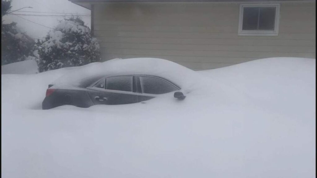
Heavy Snowfall Overwhelms Northern Communities
The storm first triggered widespread warnings as it moved into the region on Sunday. Areas including Sault Ste. Marie, Sudbury, and Kapuskasing were initially forecast to receive between 10 and 20 cm of snow mixed with ice pellets.
However, the storm strengthened quickly. By midday Monday, snowfall totals had far exceeded early forecasts, with close to 50 cm reported across several communities stretching from Sault Ste. Marie and Elliott Lake toward Timmins.
In many neighbourhoods, vehicles and driveways disappeared beneath towering snowbanks while residents worked through the day clearing pathways and digging out buried cars.
Freezing Rain and Ice Expected to Continue
Environment Canada continues to maintain winter storm warnings for communities including Sudbury, Elliott Lake, Timmins, and Manitoulin Island as the system remains active.
Forecasters say Sudbury could also see 6 to 12 millimetres of freezing rain, increasing the risk of ice buildup on roads, trees, and power infrastructure.
While most precipitation will fall as snow, some areas along the corridor between Sault Ste. Marie and Kirkland Lake could see periods of ice pellets mixing with snowfall, potentially altering accumulation totals in those locations.
Additional snowfall across northern communities may continue through Monday night before gradually easing into lighter snow.
Dangerous Travel Conditions Across Ontario
The storm has already created difficult travel conditions across many highways and local roads. Authorities warn that driving conditions could become extremely hazardous as snow continues to accumulate and icy layers develop beneath fresh snowfall.
Officials also caution that the combination of heavy snow and freezing rain may increase the likelihood of power outages and road closures across affected regions.
Travel disruptions are expected to persist until crews can clear roads and restore normal conditions.
Snow Squalls and Strong Winds Target Southern Ontario
While northern Ontario faces the heaviest snowfall, the storm system is also bringing unstable weather further south.
Several southern communities are currently under snow squall watches, with lake-effect systems expected to produce significant snowfall in localized areas.
Forecasters say Innisfil could receive up to 15 cm from lake-effect squalls, while regions such as Stratford and Owen Sound may see totals approaching 20 to 40 cm in isolated zones.
The squalls are expected to begin Monday evening and could continue into Tuesday afternoon.
Other communities including Peterborough, Belleville, and Kawartha Lakes may also experience accumulating snow, with forecasts indicating around 5 to 10 cm overnight into Tuesday morning.
High Winds Add to Storm Impacts
Wind gusts are expected to intensify the storm’s impact across southern and southwestern Ontario.
Cities including Toronto, London, Windsor, Woodstock, and Brantford could experience gusts reaching 70 to 90 km/h, raising the risk of blowing snow and reduced visibility on major roadways.
Combined with falling temperatures and ongoing snowfall, the system is expected to prolong winter conditions across much of the province even as the official start of spring approaches.
Additional updates on the evolving storm and official warnings can be found through Environment Canada’s weather alerts service.
Make Swikblog your go-to source on Google for reliable updates, smart insights, and daily trends.