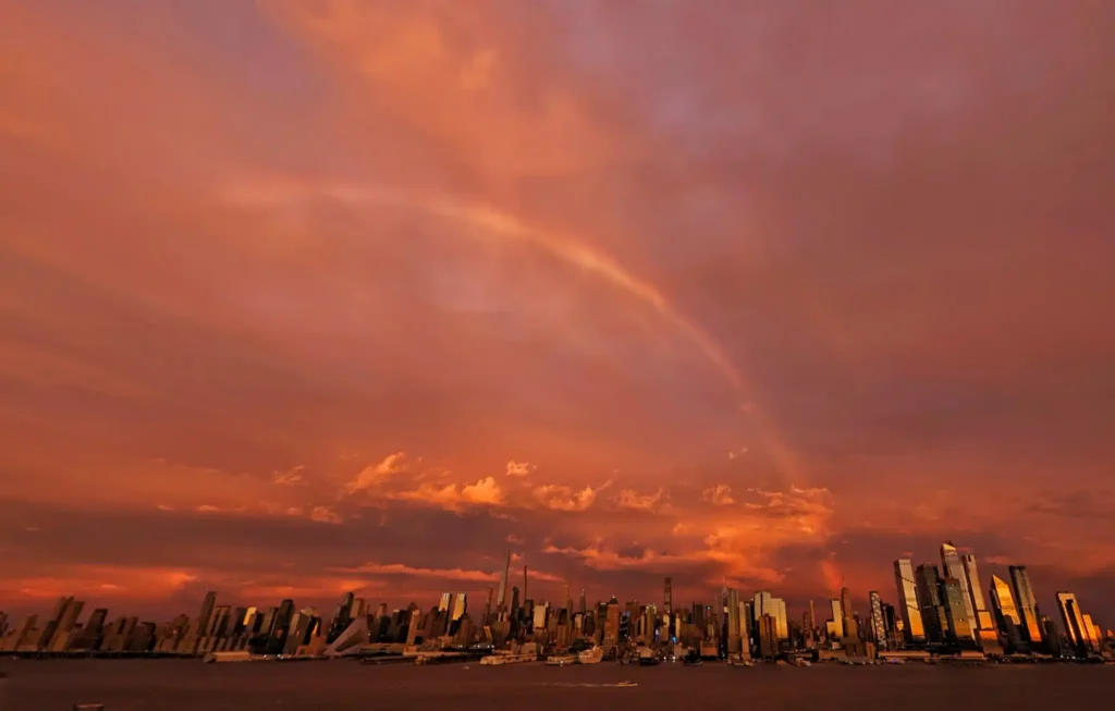

NEW YORK — New York City’s skyline turned fiery red and orange Friday evening as a rainbow appeared beneath dark storm clouds, creating a striking scene just as a nor’easter moved closer to the city with the threat of heavy rain, coastal flooding and wind gusts of up to 50 mph.
Crazy light across Manhattan with a rainbow as the sun set ahead of an approaching nor'easter storm in New York City, Friday evening #newyorkcity #nyc #newyork #sunset #noreaster #rainbow pic.twitter.com/H0ay4CFTc8
— Gary Hershorn (@GaryHershorn) September 25, 2026
The dramatic sky quickly became a visual marker of changing weather across the region. But the bigger story is the storm itself: New York City officials say its track shifted farther west, bringing the system closer to the five boroughs and increasing the expected rainfall and wind threat.
Storm track shifts closer to NYC
New York City officials said forecasts increased from roughly 1 to 1.5 inches of rain to about 2 to 3 inches citywide, with locally higher totals possible.
Wind gusts are expected to reach 40 to 50 mph, with the strongest conditions from Friday night through Saturday night. That raises the risk of fallen branches, unsecured outdoor objects and scattered power outages.
A citywide travel advisory is in effect from 2 p.m. Friday, September 25, through Sunday morning, September 27. The official New York City storm advisory urges residents to prepare for strong winds, rain and coastal flooding.
Coastal flooding adds another major risk
The National Weather Service has posted a Wind Advisory, High Surf Advisory and Coastal Flood Warning for parts of New York City as the nor’easter moves through.
Coastal flooding is especially concerning around high tide because persistent northerly and northeasterly winds can push water toward vulnerable shoreline communities.
Areas around Jamaica Bay, the Rockaways, Brooklyn waterfronts and Staten Island may experience flooding of roads and other low-lying locations. Residents in flood-prone neighborhoods should move vehicles away from vulnerable streets and avoid driving through standing water.
Dangerous surf and rip currents are another concern along exposed beaches. The combination of strong winds, high waves and elevated water levels can make conditions hazardous even before the heaviest rainfall arrives.
New Jersey declares emergency in eight counties
The storm is also prompting emergency action across neighboring New Jersey.
A State of Emergency took effect Friday evening for Atlantic, Burlington, Cape May, Cumberland, Middlesex, Monmouth, Ocean and Salem counties. Officials warned of heavy rain, strong winds, significant coastal flooding and beach erosion through the weekend.
The region recently experienced another round of severe weather that caused thousands of New Jersey power outages and flash flood warnings, highlighting how quickly heavy rain can disrupt roads and electrical service.
El Niño 2027 Warning: Record Global Heat and Extreme Weather Risks Rise
The Science Behind NYC’s Fiery Red Sky
The spectacular sunset should not be interpreted as a warning sign that the nor’easter suddenly became stronger.
When the sun sits low on the horizon, its light travels through more of the atmosphere. Shorter blue wavelengths scatter away more easily, leaving reds, oranges and pinks more visible.
Gaps in storm clouds can allow that low-angle sunlight to illuminate the underside of clouds, making the colors appear especially intense. Rain droplets elsewhere in the sky can simultaneously create a rainbow.
That combination helps explain why brilliant sunset colors and a rainbow could appear against darkening storm clouds over New York.
Weekend travel could become difficult
The National Weather Service forecast calls for periods of rain and gusty winds through Saturday, with gusts around 45 mph possible in parts of the city.
Travelers should check flight, ferry, subway and road conditions before leaving. Outdoor furniture, decorations and other lightweight objects should also be secured before stronger winds arrive.
The developing nor’easter follows another East Coast weather disruption that forced the cancellation of Ed Sheeran’s Gillette Stadium concerts as severe conditions threatened New England.
For New Yorkers, the fiery sunset may have been the most striking image of Friday evening, but attention is now turning to the more serious risks expected through the weekend: strong winds, flooding, dangerous surf and potentially difficult travel.

Make Swikblog your go-to source on Google for reliable updates, smart insights, and daily trends.