A rapidly intensifying winter storm is turning the Sierra Nevada into a high-risk zone this weekend, with updated warnings calling for up to 60 inches of snow and wind gusts reaching 90 mph along the crest. The system has escalated quickly, expanding from localized alerts into a full-scale warning covering nearly the entire mountain range — from Northern California down through Yosemite, Kings Canyon and Sequoia.
What began as a moderate spring storm has now evolved into a serious travel threat, especially for anyone planning to cross the Sierra via Interstate 80, Highway 50 or other key routes. Officials say conditions could become “very difficult to impossible” at peak intensity, with chain controls already in effect and full highway closures increasingly likely.
Storm intensifies fast with 5 feet snow and 90 mph winds
The latest forecast revisions show just how quickly this system has strengthened. Snow totals have been pushed up to as much as 5 feet above 6,000 feet, while wind projections have climbed to near 90 mph along exposed ridges. Around Lake Tahoe, snowfall is expected to range from several inches at lake level to more than two feet at higher elevations, with even heavier totals along the Sierra crest.
This is not just about snow depth. The combination of high wind, rapid snowfall rates and falling snow levels is what makes the situation more dangerous. Forecasters expect snowfall rates of 1 to 2 inches per hour during peak periods, which can quickly overwhelm road crews and reduce visibility to near zero.
Snow levels are also expected to drop sharply — from around 6,000–7,000 feet earlier in the day to as low as 4,000–4,500 feet overnight. That shift means conditions will worsen across a much wider area, bringing hazardous driving even to routes that initially see rain or slushy buildup.
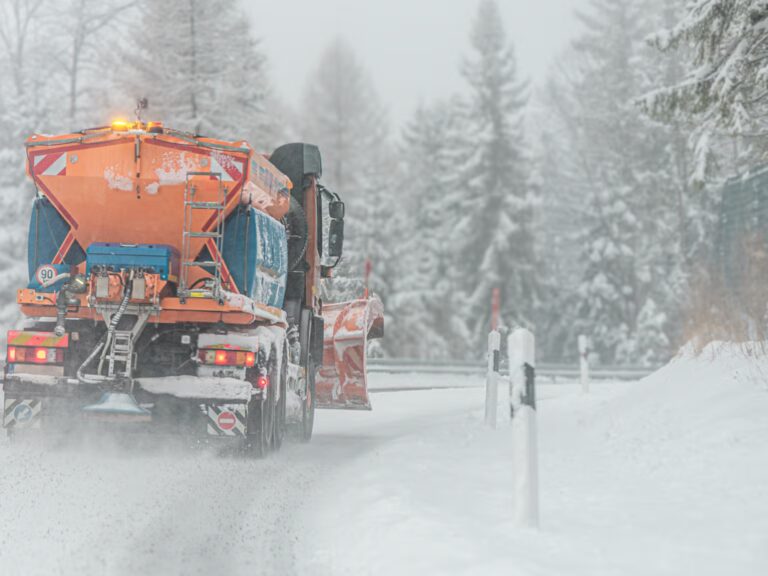
Highway closures and chain controls likely across Sierra
The biggest immediate impact is on travel. Chain controls are already active on Interstate 80, with screening checkpoints in place for trucks and strict requirements for vehicles entering higher elevations. As conditions deteriorate, these controls are expected to tighten further, with authorities warning that full closures over Donner Pass and Echo Summit are highly likely.
Interstate 80 remains one of the most critical routes across the Sierra, and when it shuts down, there is effectively no practical detour through the northern mountains. Highway 50, which connects to South Lake Tahoe, faces similar risks, especially given its elevation and exposure to heavy snowfall and wind.
Other routes including Highway 88, Highway 89 and key Yosemite corridors are also at risk of closures or severe restrictions. On the eastern side, Highway 395 could see strong winds and accumulating snow, making travel difficult even outside the heaviest snowfall zones.
Officials are urging drivers not to underestimate the situation. Even if roads remain technically open, conditions can change within minutes — turning a manageable drive into a dangerous or even stranded situation.
For real-time updates, travelers should monitor the National Weather Service and local transportation alerts before attempting any crossing.
Worst conditions expected overnight into Sunday
The most dangerous window is expected from Saturday night through Sunday morning, when a stronger second wave of the storm moves through. During this period, snow levels will be at their lowest, winds will peak near 90 mph, and snowfall rates will be at their highest.
This combination creates the highest risk for whiteout conditions, road shutdowns and extended delays. Drivers caught on mountain highways during this window could face long stoppages, poor visibility and rapidly deteriorating road surfaces.
Even after snowfall begins to ease later Sunday, conditions will not immediately improve. Clearing several feet of dense, wet snow takes time, and overnight refreezing into Monday morning can leave roads icy and hazardous well after the storm passes.
Authorities say the earliest realistic window for safer travel across the Sierra may not arrive until Monday, once crews have had time to clear and treat the highways.
For many Californians, this storm is a sharp reminder that winter conditions can return quickly in the mountains, even deep into spring. While the snowfall may ultimately benefit the state’s water supply and late-season snowpack, the immediate impact is clear — dangerous travel, potential road closures and a weekend of disruption across one of California’s most important regions.
Anyone planning to head into the Sierra should stay flexible, prepare for delays and take warnings seriously. With up to 60 inches of snow and powerful winds on the way, this is not a routine storm — it’s a high-impact event that could bring travel across the mountains to a standstill.
You may also like: Jet2 Birmingham to Madeira Flight Hit by Strong Winds, Causing Major DisruptionMake Swikblog your go-to source on Google for reliable updates, smart insights, and daily trends.