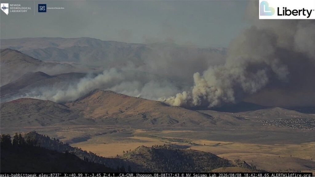

The Bug Fire burning along the California-Nevada border remained 0% contained Sunday, August 9, after growing to roughly 6,500 acres and forcing evacuations around Cold Springs and other communities in the North Valleys.
Truckee Meadows Fire Protection District said in its 8:15 a.m. Sunday update that no structures had been reported damaged in Washoe County. No injuries or structure losses had been reported, while air resources were expected to continue supporting firefighters during the day.
The wildfire started shortly after 4 p.m. Saturday, August 8. CAL FIRE said it was reported at about 4:08 p.m. near U.S. Highway 395 south of Bringman Road in Lassen County. The cause remains under investigation.
Cold Springs evacuations remain as crews battle the Bug Fire
The fire expanded rapidly during its first night, prompting evacuation orders in affected areas of Washoe County in Nevada and Lassen and Sierra counties in California. Much of Cold Springs was placed under evacuation orders Saturday night as flames moved toward populated parts of the North Valleys.
The Sunday morning report listed the fire at 6,529 acres. CAL FIRE’s later active-incident listing showed 6,528 acres with 0% containment, a one-acre difference that can occur when updated mapping refines the fire perimeter.
Before Sunday’s public update, Truckee Meadows Fire Protection District was expected to hold an internal briefing at 7:30 a.m., followed by updated information around 8 a.m. The morning report confirmed no reported structure damage in Washoe County and continued use of aircraft in the firefighting response.
Wildfires close to residential areas can create evacuation pressure even before homes are damaged. The Sandy Fire near Simi Valley prompted evacuation orders near neighborhoods as crews responded to another fast-moving vegetation fire in California.
1,280 NV Energy customers reported without power
The Bug Fire also disrupted electricity service in northern Nevada. NV Energy reported 1,280 customers without power Sunday morning, with most of the outages affecting the North Valleys, including Cold Springs.
The utility listed the interruption as a shutdown connected to an active wildfire and showed 12:30 p.m. Sunday as the estimated restoration time in the morning report.
Power loss can make evacuations more difficult by affecting home internet connections and the ability to charge phones while emergency instructions are changing. Residents should continue relying on official local alerts for evacuation decisions.
Wildfires can also affect travel beyond the immediate burn area. The Pocket Fire near Sedona forced evacuations and closed SR 89A, showing how quickly road access can become part of a wildfire emergency.
Current statewide acreage and containment information is available through the official CAL FIRE incident page.
Read More
• Jasper Fire Near Malibu Canyon as Crews Protect Calabasas
• Moreno Valley Fire Burns 1,000 Acres as Evacuations Are Ordered
Why 0% containment still matters
A 0% containment figure does not mean crews have made no progress. It means officials have not yet secured enough of the fire perimeter with control lines to report measurable containment.
For residents near Cold Springs, evacuation status remains more important than small changes in acreage. The fire was still active Sunday, aircraft remained part of the response, and authorities continued treating nearby communities as potentially at risk despite the absence of reported injuries or structure losses.
Wildfire acreage, containment, evacuation boundaries and power outages can change as new field reports and mapping become available.

Make Swikblog your go-to source on Google for reliable updates, smart insights, and daily trends.