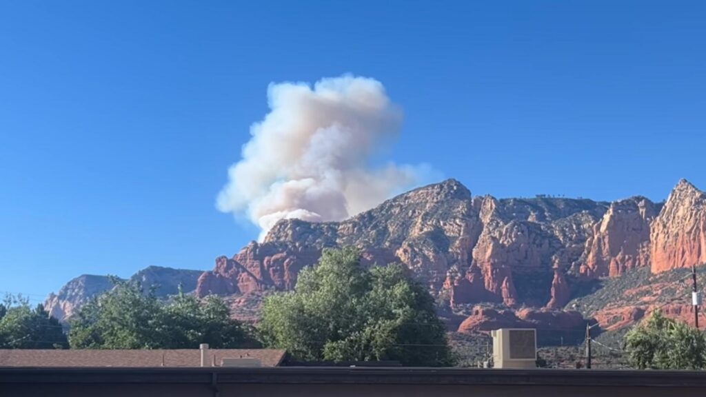

A wildfire burning in Arizona’s Coconino National Forest has prompted evacuation orders, forced a lengthy highway closure, and disrupted travel for visitors heading to Sedona. Known as the Pocket Fire, the blaze started on June 19 near East Pocket, an area widely recognized as the “Edge of the World,” roughly seven miles north of Sedona. Fire officials estimate the wildfire has spread across about 100 acres as crews continue working to slow its advance.
Updated: June 29, 2026
Although the Pocket Fire remains relatively small compared with Arizona’s largest wildfires, its location near popular recreation areas and one of northern Arizona’s busiest scenic highways has led to an aggressive emergency response. Firefighters continue monitoring weather conditions, dry vegetation, and shifting winds that could influence how the fire behaves.
GO Evacuation Orders Remain in Effect
Coconino County officials have issued GO evacuation orders for visitors, campers, and residents in parts of Oak Creek Canyon between Sedona and Forest Highlands. The evacuation area includes dispersed camping locations near West Fork and several sites above the Mogollon Rim.
A GO notification is the highest level of Arizona’s Ready, Set, Go evacuation system. It tells people to leave immediately because changing fire conditions could quickly reduce the time available to evacuate safely.
Officials have not reported injuries or damage to homes or businesses. Emergency crews continue assessing conditions while monitoring whether evacuation zones need to be expanded or modified.
State Route 89A Closed as Firefighting Continues
The wildfire has forced the closure of roughly 23 miles of State Route 89A between Sedona and Interstate 17. The highway is a major travel corridor connecting local communities while providing access to Sedona’s hiking trails, scenic overlooks, campgrounds, and tourism destinations.
Drivers have also been advised to avoid Woody Mountain Road, also known as Forest Road 231, where firefighting vehicles and equipment continue operating.
For anyone planning travel through northern Arizona, the incident is another reminder that wildfire activity can disrupt transportation with little notice, particularly during the state’s peak fire season.
Specialized Fire Crews and Aircraft Deployed
Fire managers have assigned two Hotshot crews, five fire engines, one bulldozer, and aviation resources to battle the blaze. These teams are working to strengthen containment lines, protect nearby recreation areas, and prevent further spread.
Hotshot crews are among the most experienced wildland firefighters in the United States. They are specially trained to operate in steep, rugged terrain where fires can spread rapidly and access is limited.
The Sedona Fire Department continues coordinating with federal, state, and local agencies throughout suppression operations. Investigators have not yet determined what caused the fire.
Smoke Affecting Nearby Communities
Smoke from the Pocket Fire has been visible from Cottonwood and surrounding areas, illustrating that wildfire impacts often extend well beyond evacuation zones. Even relatively small fires can reduce visibility and temporarily lower air quality across neighboring communities.
People with asthma, respiratory illnesses, or heart conditions are generally advised to reduce prolonged outdoor activity when wildfire smoke becomes noticeable. Motorists should also remain alert for rapidly changing visibility along highways near the fire area.
Arizona experiences regular wildfire activity during periods of hot, dry weather, making preparation especially important for campers and visitors exploring remote forest locations where evacuation routes may be limited.
Learning practical bushfire safety measures during extreme weather events can help families and outdoor travelers respond more confidently if wildfire conditions worsen.
Read More
What Officials Are Monitoring Next
Fire managers will continue evaluating weather forecasts, fuel conditions, and fire behavior while deciding whether more personnel or aircraft are required. Evacuation notices and road closures remain subject to change as firefighters gain a better understanding of conditions on the ground.
Officials have not yet released a containment percentage, confirmed the cause of the wildfire, or announced when State Route 89A will reopen to normal traffic.
Residents and travelers are encouraged to follow updates from local emergency agencies and the official Pocket Fire information page for verified information on road access, evacuation notices, and firefighting progress.
For now, crews remain focused on slowing the Pocket Fire, protecting nearby communities and recreation areas, and restoring safe travel through one of northern Arizona’s most visited regions as conditions allow.

Make Swikblog your go-to source on Google for reliable updates, smart insights, and daily trends.