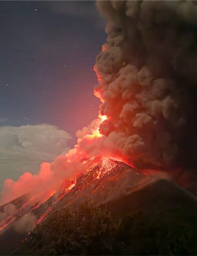

Guatemala’s Volcán de Fuego produced a dramatic fiery explosion on August 9, sending incandescent material above its crater and creating a pressure wave powerful enough to shake a nearby monitoring camera.
The burst, recorded at approximately 4.30am on August 9, quickly attracted attention online because of its intensity. Bright orange volcanic material can be seen rising from the summit against the night sky before the force of the explosion reaches the camera several seconds later.
The footage emerged only days after a much larger eruptive episode forced approximately 1,700 residents from at least 18 communities to leave their homes. Although Guatemala’s monitoring agency had reported that the main eruptive phase had subsided, Fuego remained capable of producing intermittent explosions as it returned to its usual pattern of activity.
A powerful explosion after days of disruption
Large eruptive burst at Guatemala's Volcán de Fuego (Mt Fuego) on August 9, followed by a powerful shock wave that rattles the camera. pic.twitter.com/6bvLlWWReR
— Pacific Wire (@ChynoNews) August 10, 2026
Fuego entered an intense eruptive phase on August 3, producing columns of gas and ash, lava activity and dangerous pyroclastic density currents descending through several ravines on its slopes.
The emergency prompted precautionary evacuations in communities including El Porvenir and Las Lajitas. Authorities also closed National Route 14 near the volcano and suspended classes in affected municipalities across Sacatepéquez, Escuintla and Chimaltenango.
Ashfall affected surrounding settlements while officials warned that volcanic material could travel considerable distances depending on wind conditions. Around 29,000 people were estimated to have been affected by ash and related disruption during the heightened activity.
After approximately 50 hours, Guatemala’s volcanic monitoring institute reported that Fuego had returned to its normal operating parameters. That declaration did not mean the volcano had become completely quiet. Fuego is persistently active and can continue producing weak or moderate explosions even outside a major eruptive crisis.
This distinction is important when interpreting the August 9 footage. A visually spectacular explosion does not, by itself, confirm the beginning of another major eruption. Scientists assess several indicators—including seismic signals, ash-plume height, gas emissions, lava output and the movement of hot material down the volcano’s ravines—before declaring a new eruptive phase.
Residents are being advised to follow updates from Guatemala’s National Coordinator for Disaster Reduction, which continues to publish official information and safety guidance for communities surrounding the volcano.
Rain keeps the lahar threat alive
The most immediate danger is not limited to fresh explosions. Rain can combine with ash, rocks and loose volcanic debris to produce fast-moving mudflows known as lahars.
During the early-August crisis, volcanic flows travelled as far as seven kilometres through some channels. Authorities warned residents not to enter or remain near rivers and ravines because a lahar can arrive suddenly, carry large boulders and damage roads or structures in its path.
The risk can remain elevated after explosive activity decreases. Material deposited on the upper slopes may be remobilised by heavy rain days or even weeks later, extending the danger beyond the most visible stage of an eruption.
Fuego rises to approximately 3,768 metres and lies about 50 kilometres south-west of Guatemala City. It is one of Central America’s most active volcanoes, with frequent explosions forming part of its normal behaviour. Communities on its slopes nevertheless face serious risks whenever those explosions intensify or generate pyroclastic flows.
The volcano’s destructive potential remains deeply embedded in Guatemala’s recent history. In June 2018, a catastrophic eruption sent pyroclastic flows into nearby communities, killing more than 100 people and leaving many others missing. The disaster transformed the way authorities approach evacuations and emergency alerts around Fuego.
A similarly powerful combination of ash and volcanic material shaped the recent Ethiopia volcano eruption, demonstrating that the dangers created by explosive volcanoes can extend far beyond their craters.
The August 9 burst offers another vivid demonstration of Fuego’s continuing power, but its scale should not be judged from online footage alone. For nearby residents, the decisive information will continue to come from scientific monitoring, official evacuation instructions and changing assessments of rainfall, ash dispersal and activity inside the crater.

Make Swikblog your go-to source on Google for reliable updates, smart insights, and daily trends.