Powerful winds sweeping across Colorado’s Front Range caused widespread disruption Thursday, knocking out electricity for thousands of residents, closing major highways and forcing schools and universities to shut down operations. The extreme weather event, driven by a rare atmospheric setup known as a “mountain wave,” brought wind gusts exceeding 90 mph in parts of the state and created dangerous travel conditions across Northern Colorado.
Among the biggest impacts were Xcel power outages reported across several communities as strong gusts damaged infrastructure and toppled trees. Thousands of residents suddenly found themselves without electricity while emergency crews responded to outages, debris and fire risks caused by the storm.
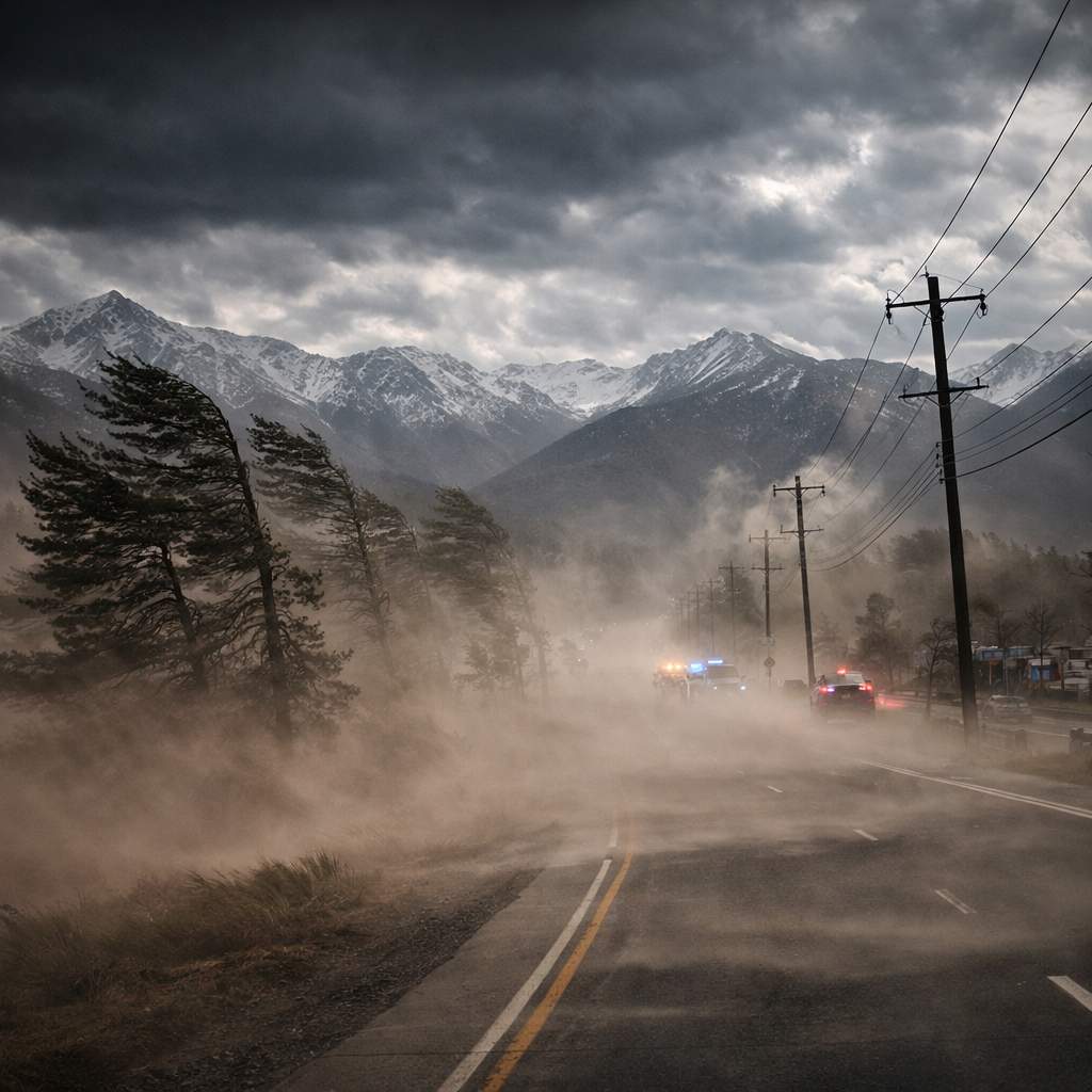
The intense windstorm also led to temporary closures along Interstate 25 from Fort Collins to the Wyoming state line before authorities eventually reopened the highway later in the evening. U.S. Highway 85 was also shut down due to dangerous driving conditions caused by powerful gusts and blowing dust.
Mountain Wave Phenomenon Behind Colorado’s Extreme Winds
Meteorologists say the unusual wind event was driven by a weather pattern known as a mountain wave, which frequently affects regions on the eastern side of major mountain ranges like the Rocky Mountains.
This phenomenon occurs when strong winds move from west to east across the mountains and encounter a stable layer of air above the Front Range. As the air flows up and over the mountains, it cannot rise further due to the stable atmosphere above it. Instead, it is compressed and forced downward along the eastern slopes.
As the air is squeezed through a smaller atmospheric space, its speed increases dramatically. By the time the air descends toward the Denver metro area and surrounding plains, it can generate extremely powerful wind gusts capable of causing widespread damage.
This pattern is one reason the Front Range frequently experiences sudden windstorms that can intensify within hours.
Xcel Power Outages Leave Thousands Without Electricity
The severe winds quickly translated into infrastructure problems across Northern Colorado. As gusts intensified, power lines were damaged by falling tree branches and airborne debris, triggering Xcel power outages that affected thousands of residents.
Strong windstorms create difficult conditions for electrical systems. Trees can fall into lines, utility poles can be damaged and debris carried by wind can disrupt equipment. In some situations, power companies also take proactive measures to reduce wildfire risk by temporarily shutting off electricity in vulnerable areas.
Residents were urged to stay away from downed power lines and report any damage immediately. Officials also encouraged people to prepare for outages during high wind events by keeping flashlights, battery packs and emergency supplies ready.
For updates on outages and restoration efforts, residents can check official reports on the Xcel Energy outage center.
Highway Closures and Dangerous Driving Conditions
Travel conditions quickly became hazardous across Northern Colorado as the windstorm intensified. Interstate 25 was temporarily closed between the Prospect Road exit in Fort Collins and the Wyoming state line due to strong crosswinds and dangerous driving conditions.
Authorities reported that high-profile vehicles such as semi-trucks were particularly vulnerable to tipping in extreme winds. Several semitrailers were reportedly blown over during the storm, prompting emergency road closures and safety warnings.
In addition to the I-25 shutdown, U.S. Highway 85 from Weld County Road 100 to the Wyoming border was also closed during the peak of the storm. Both highways eventually reopened once conditions improved later in the evening.
Drivers were advised to avoid unnecessary travel and stay alert for sudden wind gusts, reduced visibility and debris on roadways.
Colorado State University Closes Campus Due to Wind Damage
The storm’s impact extended beyond transportation and power outages. Colorado State University announced that its main campus in Fort Collins and other campuses in Larimer County would close on March 13 after strong winds caused significant damage across campus.
University officials said fallen trees and broken branches were blocking walkways and creating potential safety hazards for students and staff. Because additional limbs could still fall during ongoing windy conditions, the university canceled all in-person, hybrid and remote classes and suspended most operations for the day.
Residence halls, dining facilities and the campus Transit Center remained open for students living on campus, but those who needed to move around outside were advised to use extreme caution.
Dry Winter Increases Fire Risk Across Colorado
The powerful winds come after what meteorologists describe as a historically dry and warm winter across Colorado. Since December 1, 2025, the region has experienced at least 11 Red Flag Warnings — alerts issued when weather conditions make wildfires more likely to start and spread rapidly.
Low soil moisture across the Front Range means dust and dry vegetation can easily be lifted into the air during strong windstorms. This increases both fire danger and visibility problems for drivers.
In fact, similar blowing dust conditions earlier this year contributed to a deadly multi-vehicle crash on Interstate 25 involving more than 30 vehicles. The accident created dangerous “brownout” conditions that severely reduced visibility and tragically resulted in four fatalities.
Officials say the same combination of dry ground, powerful winds and low humidity can quickly turn a small grass fire into a rapidly spreading wildfire.
Residents were strongly advised to avoid outdoor burning, secure loose objects around homes and stay alert for emergency alerts during high wind and Red Flag Warning periods.
What Residents Should Expect Next
While the strongest winds have passed, officials say cleanup and recovery efforts may continue for several days as crews repair damaged infrastructure and clear fallen trees and debris.
High wind events remain a recurring challenge for Colorado’s Front Range communities due to the region’s unique geography and weather patterns. When mountain wave conditions develop, winds can intensify rapidly and affect everything from power grids to transportation networks.
Residents across Colorado are encouraged to stay informed through local alerts and official travel updates from the Colorado Department of Transportation. Monitoring conditions during major windstorms can help drivers avoid dangerous routes and prepare for sudden changes in weather.
Thursday’s storm served as another reminder of how powerful Colorado’s weather systems can become. With gusts exceeding 90 mph, widespread Xcel power outages, highway closures and campus shutdowns, the event highlighted how a single mountain wave pattern can quickly disrupt daily life across the entire Front Range.
Make Swikblog your go-to source on Google for reliable updates, smart insights, and daily trends.