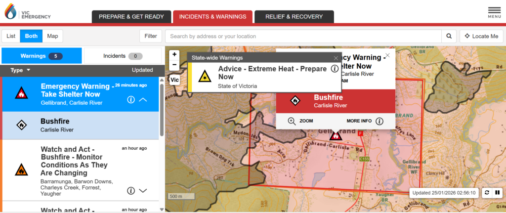
Update (Victoria): As of 2:56am AEDT on 25 January 2026, the VicEmergency map shows an active Emergency Warning – Take Shelter Now for the bushfire at Carlisle River, with the warning zone covering Gellibrand and surrounding rural areas. The image highlights the defined fire perimeter and exclusion zone, while a state-wide Extreme Heat – Prepare Now advisory remains in effect as hot conditions continue to increase bushfire risk.
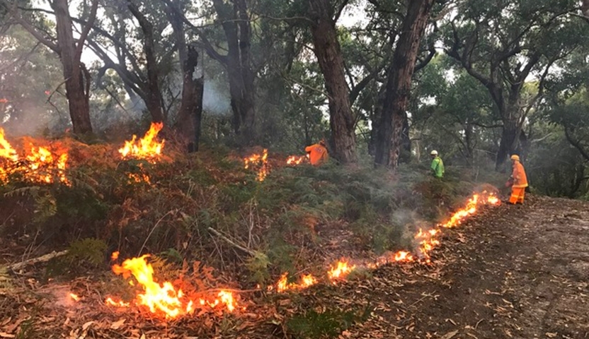
A bushfire burning in Victoria’s Otways has broken containment lines amid extreme heat, triggering emergency warnings for multiple communities in the state’s south-west as firefighters battle rapidly changing conditions.
Emergency update
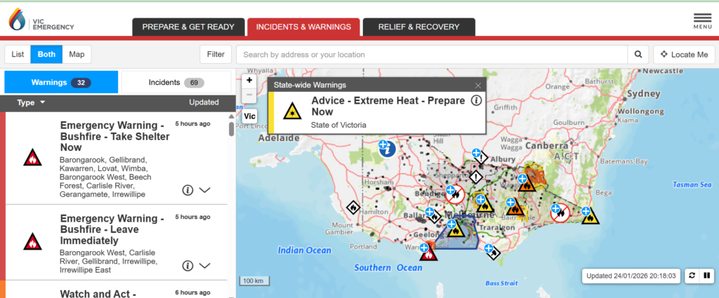
The latest map from VicEmergency shows multiple Emergency Warnings in effect across Victoria, with “Take Shelter Now” and “Leave Immediately” alerts issued for communities near the Otways bushfire. Authorities say extreme heat and gusting winds are increasing fire danger statewide.
Emergency Warnings are in place for communities south and east of the fire near Carlisle River. Authorities warn conditions are dangerous and may change quickly due to wind shifts and ongoing heat.
The fire, burning near Carlisle River and Gellibrand, escaped control lines on Saturday as temperatures climbed into the high 30s and low 40s across much of Victoria. Fire agencies say north-westerly winds pushed the blaze beyond containment on the south-eastern edge, creating a fast-moving and unpredictable fire front.
Communities including Beech Forest, Carlisle River, Charleys Creek, Ferguson, Gellibrand and Wyelangta were among those told it was too dangerous to leave and that residents should take shelter immediately. A separate “leave immediately” warning was later issued for towns to the east and north-east of the fire, including Barongarook, where the blaze was expected to move following a wind change.
A bushfire in Victoria’s Otways has broken containment lines and is threatening communities south and east of the fire. Conditions have been driven by extreme heat and shifting winds, increasing the risk of embers starting spot fires well ahead of the main front. If you’re in an at-risk area, keep checking official warnings and act early.
What “breaks containment lines” actually means. A containment line is a control boundary built or strengthened by firefighters — sometimes a dozer line, sometimes a road, a creek, or a planned burn edge — designed to stop a fire’s spread. When a fire breaks those lines, it signals that flames, embers, wind, terrain or fuel loads have overcome the control plan. It doesn’t automatically mean the worst, but it does mean the fire is behaving aggressively enough that crews must reset strategy, protect communities, and attempt to establish new control points.
COMMUNITY INFORMATION
— VicEmergency (@vicemergency) January 24, 2026
Smoke in the Otways, Geelong, Metropolitan Melbourne, Mornington Peninsula, Phillip Island and surrounds.
Do not call Triple Zero (000) unless you see a fire or a defined column of smoke. https://t.co/IhlpmhgBqp pic.twitter.com/ZN7diFwLOD
Forest Fire Management Victoria state agency commander Steve Pellicano said the fire plume was several metres high and described the situation as highly dynamic. Fire behaviour, he said, was being driven by ongoing winds and extremely dry forest fuels, with crews concerned about the direction the fire could take as conditions evolved.
Authorities say the Otways’ dense forest and rugged terrain are making firefighting efforts more complex. While ground crews have been deployed to protect towns and farms along smaller access roads, aircraft — including a large air tanker — have been operating above the fireground in an effort to slow its spread.
Bushfire jumps containment lines in Victoria's Otways as temperatures soar – ABC News https://t.co/YWYDqrBXcX
— Jason Birch (@JasonBirch0916) January 24, 2026
State Control Centre spokesperson David Nugent said the fire remained very active as winds gusted up to 40 kilometres an hour. “These conditions make containment difficult,” he said, noting that shifting winds were complicating both aerial and ground operations.
Mayor of the Colac Otway Shire Jason Schram said he had not received reports of homes being lost but urged residents to act on warnings early. He said the fire-affected area included not only thick bushland but also farms and properties accessed by narrow roads, increasing risk if residents delayed action.
Smoke from the Otways fire has spread well beyond the immediate fire zone, prompting air-quality alerts across the Otways, Geelong, Melbourne’s south-eastern suburbs, the Mornington Peninsula and parts of Phillip Island. Health authorities advise people with respiratory or heart conditions to limit outdoor activity if smoke levels increase.
The Otways blaze is one of several significant fires burning across Victoria. Other major fires remain active in areas including Walwa in the north-east, Longwood in central Victoria, and Mallacoota and the Wonnangatta Valley in the east, where Watch and Act warnings remain in place.
A bushfire in Victoria's Otways, near Gellibrand, has broken containment lines and is threatening communities south and east of the fire.https://t.co/QeF07Tk8sa
— Gary Buckley™ (@myrddenbuckley) January 24, 2026
Emergency Management Commissioner Tim Wiebusch said while conditions were not as severe as earlier in the month, when hundreds of thousands of hectares burned statewide, the ongoing heatwave meant fire danger remained high to extreme across large parts of Victoria. A total fire ban was declared across the state on Saturday.
Authorities warn the heat is expected to continue, with warm overnight temperatures adding further strain on firefighters and communities. Residents are urged to monitor official warnings closely and follow instructions issued through VicEmergency, which provides real-time updates by location.
What this means for the next 24 hours. When extreme heat lingers, firefighters face a narrower window for containment work. Nights can offer some relief — but if winds stay up and fuels remain dry, fires can continue to run after dark. For everyone watching from Melbourne, the practical takeaway is not panic, but preparedness: know where your information is coming from, avoid unnecessary travel into high-risk regions, and treat official warnings as instructions, not suggestions.
More Australia emergency updates are available on Swikblog.
Make Swikblog your go-to source on Google for reliable updates, smart insights, and daily trends.