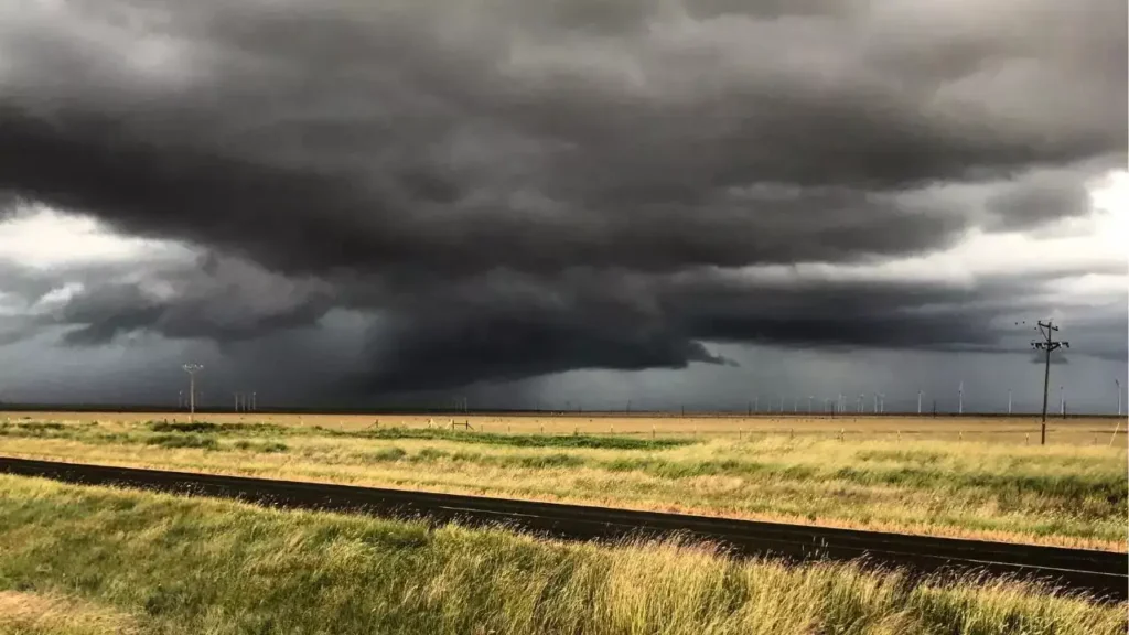
Fresno County saw an unusual and fast-changing stretch of weather on Tuesday after the National Weather Service confirmed that two tornadoes touched down in the region within a matter of hours, turning what began as a spring storm system into one of the most talked-about weather events in the Central Valley this year.
The first touchdown was reported near Biola at about 2:15 p.m., placing the tornado roughly eight miles west of Fresno. That confirmation immediately raised the seriousness of the situation because tornadoes remain rare in this part of California, even during active spring weather patterns. A tornado warning was issued for parts of Fresno and Madera counties and remained in place until 3 p.m., while residents across the area received emergency alerts urging them to move to safety.
For many people in the Valley, the alerts felt startling not because storms are unheard of, but because tornado warnings are still outside the kind of weather routine most locals expect. In the middle of the afternoon, phones lit up, weather updates spread quickly, and attention shifted from ordinary daily activity to the possibility of dangerous wind, flying debris and rapidly changing conditions.
Once the initial tornado warning expired, the threat did not disappear. The National Weather Service followed with a severe thunderstorm warning for the same storm cell affecting south central Madera County and northwest Fresno County. That alert lasted until 3:30 p.m. and reflected the fact that while the confirmed tornado threat had eased in that moment, the system still carried enough strength to produce damaging weather. In practical terms, it meant the region was not dealing with one brief burst of instability, but with a storm capable of continuing to evolve as it moved along.
Warnings, school precautions and a second touchdown
The afternoon’s weather also had an immediate impact on schools and families. In the Fresno area, a tornado warning led Clovis Unified to issue a shelter-in-place order for about 30 minutes. That response underscored how seriously officials treated the situation. Even brief warnings can force quick decisions when student safety is involved, especially when weather develops in a way that leaves little room for delay.
A funnel cloud was also spotted near Highway 99 and Herndon, adding to the tension surrounding the storms. But while that image quickly drew attention, the National Weather Service later clarified an important distinction: the funnel cloud seen in Fresno did not touch down. The confirmed tornado near Biola remained the first verified touchdown from the day’s severe weather.
Then the story changed again later in the day. At about 5:17 p.m., the National Weather Service issued a second tornado warning, this time covering northeastern Fresno County toward Auberry. That warning remained in effect until 5:45 p.m. and marked a second confirmed tornado touchdown tied to the same broader weather outbreak. By that point, what had already been an unusual weather day had become even more remarkable. Two separate tornadoes in Fresno County on the same day is not the kind of event residents see often, if at all.
As the evening progressed, both storms moved into the mountains, where another weather hazard was already in focus. A winter storm warning remained in effect in the higher elevations through Wednesday at 5 p.m., showing just how broad the system’s reach had become. The same setup that produced severe thunderstorm and tornado conditions in the lower elevations was also feeding wintry weather deeper into the Sierra. That contrast captured the complexity of Central California weather during strong spring transitions: severe local storms in one zone, winter conditions in another.
Why this weather event matters
Tornadoes in the Central Valley are uncommon, but not impossible. The region typically records only one or two tornado reports in a year, which helps explain why Tuesday’s double touchdown stood out so sharply. The last widely noted Fresno County tornado before this event occurred in Clovis in 2019. That gap alone is enough to show why many residents saw Tuesday’s warnings as extraordinary rather than routine.
There is also an important public-safety lesson in the sequence of events. The difference between a funnel cloud and a tornado can be significant, and official confirmation matters. A funnel cloud may look dramatic, but it does not become a tornado unless it reaches the ground. In Tuesday’s case, the National Weather Service confirmed two actual touchdowns, which made the warnings more than precautionary. They reflected real, active danger. That is why cellphone alerts, school precautions and local weather coverage became so urgent in a short period of time.
For readers following Valley weather closely, this event is also a reminder that California’s risk profile is broader than many people assume. Heat, wildfire smoke and drought may define much of the state’s weather conversation, but spring storm systems can still produce severe thunderstorms, hail, funnel clouds and even tornadoes under the right conditions. The National Weather Service remains the most reliable source for those fast-moving updates, forecasts and safety guidance, especially when weather begins to shift by the hour. Readers can review official storm resources through the National Weather Service.
For Fresno County, the bigger story is not just that tornadoes touched down. It is that the region was reminded, in real time, how quickly weather can disrupt routines, trigger school action, send alerts across thousands of phones and change the tone of an ordinary Tuesday. That is often how weather events leave a lasting mark: not only through damage, but through the sudden awareness that even familiar places are not immune to rare and dangerous conditions.
Tuesday’s storms will likely be remembered as one of those rare days when Fresno County weather broke from expectations. Two confirmed tornado touchdowns, multiple warnings, a brief school shelter order and mountain winter weather all unfolded from the same system. For a region that rarely finds itself at the center of tornado coverage, that alone made it a day residents are unlikely to forget anytime soon.
You may also like: Tornado Warnings in Wisconsin Bring Severe Storms and Flood Risk in April 2026.
Make Swikblog your go-to source on Google for reliable updates, smart insights, and daily trends.