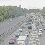
Heavy rainfall across Queensland’s Gold Coast has triggered criticism of Australia’s weather forecasting system after several suburbs recorded rain totals far above official predictions, leading to flash flooding, damaged property and dangerous road conditions.
The Bureau of Meteorology (BOM) had forecast between 60mm and 80mm of rain for the region on Monday. Instead, parts of the Gold Coast hinterland and northern suburbs recorded close to 200mm in just 24 hours, with some locations experiencing their wettest May day since 2003.
The sudden downpour caught many residents and community organisations off guard. Johnny Simpson, president of the Parkwood Sharks Rugby League Club, said floodwaters rapidly entered the club’s facilities during the afternoon as rain intensified faster than expected.
Club volunteers spent hours trying to save equipment and clear water from the building, but significant damage was already done. Newly purchased equipment was ruined, while sections of the clubhouse are expected to require major repairs including stripped walls and flood restoration work.
Residents in Mudgeeraba and nearby hinterland areas also reported rainfall totals much higher than expected. Local resident Barry Lubke said his personal rain gauge measured around 133mm, more than double what many people believed was likely based on public forecasts.
At the Mudgeeraba showgrounds, coffee van operator Tiffany Leihn said floodwaters from a nearby creek rose quickly while she was packing up on Monday evening. By Tuesday morning, debris and mud were scattered across the area after the water receded.
Why the rainfall forecast failed
According to the Bureau of Meteorology, two separate weather systems — a coastal trough and a rainband — combined over South East Queensland and unexpectedly intensified rainfall across the Gold Coast.
BOM senior forecaster Felim Hanniffy explained that although rainfall totals were significant, the rain mainly fell steadily over long periods rather than reaching the bureau’s technical threshold for “heavy rainfall” warnings within six-hour windows.
That explanation has frustrated some residents and local officials who believe communities still needed stronger alerts about the potential flood danger.
Gold Coast councillor Glenn Tozer said the rainfall created dangerous situations near roads, creek crossings and low-lying areas. He acknowledged forecasting weather is difficult but said residents had a right to feel disappointed by the lack of warning before the flooding began.
Queensland Premier David Crisafulli also renewed calls for greater investment in forecasting technology, weather radars and flood gauges. He said state and local governments depend on accurate weather information when making critical emergency decisions.
Current severe weather warnings and flood updates remain available through the Bureau of Meteorology Queensland warning service.
Read More
Growing concern over extreme rainfall events
The Gold Coast flooding comes as Australia continues to experience increasingly disruptive rain events linked to volatile weather patterns. Communities across Queensland have repeatedly faced flash flooding, damaged infrastructure and evacuation threats during major storms this year.
Swikblog recently covered another major Australian weather emergency in its report on extreme flooding that followed 620mm rainfall in the Northern Territory, highlighting how quickly rainfall systems can overwhelm roads and local services.
For many Gold Coast residents, Monday’s storm has become another example of how rapidly weather conditions can escalate — and how critical accurate forecasting and timely warnings have become for communities facing severe rainfall events.
Make Swikblog your go-to source on Google for reliable updates, smart insights, and daily trends.