Peace River residents are being asked to stay prepared after officials issued a flood alert for parts of the northern Alberta town, warning that some neighbourhoods may need to evacuate quickly if river conditions worsen.
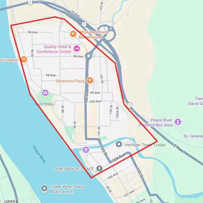
The alert applies to residents in areas stretching from the Highway 2 Bridge to 104 Avenue in the south end of Peace River. The downtown core and locations close to the Heart River are also included in the warning zone.
No evacuation order had been issued at the time of the alert, but local officials have urged people in the affected areas to prepare as though they may need to leave with very little notice. The town has advised residents to fuel vehicles, gather important documents, pack medication, prepare food and water, and make arrangements for pets.
Officials have also warned that anyone forced to leave should be ready to stay away from home for at least three days. That guidance is meant to give families enough time to prepare for a short-term displacement if flooding affects roads, homes, businesses, or essential services.
Why Peace River is facing a flood alert
The immediate concern is tied to an ice jam upstream from Peace River. Ice jams can block or restrict water movement, causing river levels to rise suddenly. If the jam shifts, breaks, or forces water into nearby low-lying areas, flooding can develop much faster than during a normal spring rise.
In this case, attention has focused on the Smoky River, an important tributary that flows into the Peace River upstream from the town. When ice builds up in that part of the river system, it can increase pressure downstream and create uncertainty for communities located near the water.
According to Alberta Emergency Alert, official warnings are used to notify the public about immediate or developing risks, including floods and other hazards. Residents in Peace River have been told to follow official updates closely and avoid areas near waterways while the situation remains active.
Flooding caused by ice jams is especially difficult to predict because conditions can change within a short period. A river may appear stable for hours before water levels rise quickly due to a shift in ice or flow. That is why officials often issue alerts before an evacuation order becomes necessary.
What residents should do now
People living in the affected part of Peace River should use the alert period to prepare calmly and carefully. Vehicles should have enough fuel to leave the area if needed. Essential documents such as identification, insurance papers, medical records, banking information, and property documents should be placed in a waterproof bag or folder.
Medication should be packed in advance, especially for people who depend on daily prescriptions. Families should also prepare basic supplies, including drinking water, ready-to-eat food, phone chargers, warm clothing, flashlights, and items for children or elderly relatives.
Pet owners should keep carriers, food, leashes, medication, and vaccination records ready. In fast-moving emergencies, pets are often one of the most difficult things to organize at the last minute, so early preparation can reduce stress if an evacuation order is issued.
Residents should also avoid walking, driving, or gathering near riverbanks, bridges, or low-lying areas. Floodwater and ice movement can be dangerous even before a wider evacuation is ordered. Roads near waterways may become unsafe quickly, and water depth can be difficult to judge from a vehicle.
Downtown Peace River businesses may also need to prepare for disruption. Owners should consider securing important records, protecting electrical equipment where possible, and monitoring official notices for any change in access or safety guidance.
The warning has not been issued for the entire town, but the affected area includes important residential, commercial, and river-adjacent zones. Residents outside the alert area should still remain aware of updates, especially if they travel through downtown or near the Heart River.
Peace River is located about 385 kilometres northwest of Edmonton and sits in a river valley where spring conditions can create sudden challenges. Seasonal thaw, moving ice, and changing river flow can combine to raise flood risk in a short window of time.
For now, the main message from officials is preparation, not panic. The alert gives residents time to make practical decisions before conditions become more urgent. If an evacuation order is issued, people should leave immediately and follow the route and instructions provided by emergency officials.
Authorities are continuing to monitor the river system and surrounding areas. Until the flood risk eases, residents in the warning zone should keep phones charged, watch for official alerts, check on neighbours who may need help, and be ready to move quickly if the situation changes.
Feature image prompt: A realistic 1:1 Google Discover-style image of Peace River, Alberta during spring flood risk, showing a cold river valley, partially broken ice on the water, cloudy sky, downtown buildings in the distance, and an emergency alert atmosphere without text overlay.
You may like: Waiwera Emergency: Auckland Landslip Forces Evacuations
Make Swikblog your go-to source on Google for reliable updates, smart insights, and daily trends.