Rapid intensification raises alarm across Western Australia
Tropical Cyclone Narelle is intensifying rapidly off the Western Australia coast, triggering widespread warnings as meteorologists flag a potential escalation to Category 5 strength. The system, currently tracking parallel to the Pilbara coastline, is expected to strengthen further over warm ocean waters before turning south toward land.
According to the Bureau of Meteorology, Narelle has already reached severe cyclone status and could develop into a Category 4 or even briefly Category 5 system offshore, with wind gusts potentially exceeding 200–220 km/h near its core.
Pilbara region already battered by destructive conditions
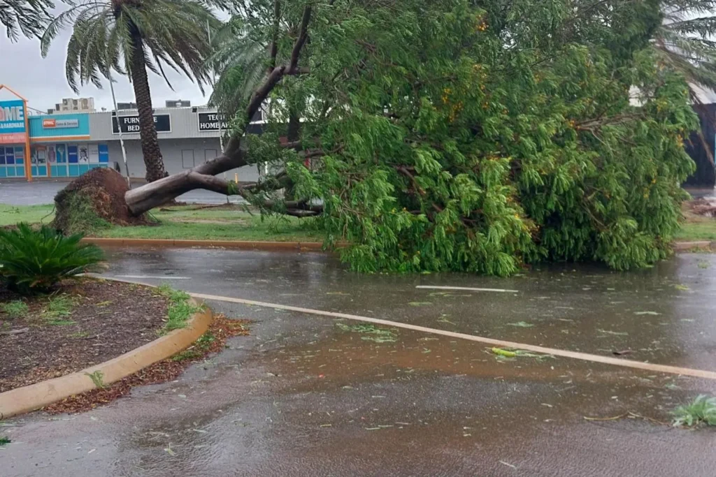
Even before making landfall, the cyclone’s outer bands have slammed the Pilbara region, bringing fierce winds, heavy rainfall, and infrastructure disruption. Coastal hubs including Port Hedland, Karratha, Dampier, and Exmouth have reported wind gusts ranging from 80 km/h on the mainland to more than 140–150 km/h offshore.
Authorities confirmed fallen trees, widespread debris, and power outages in several areas, particularly in Exmouth and Dampier. Emergency crews have been deployed but warned that response times may be delayed due to unsafe conditions.
Residents have been urged to remain indoors as stormwater surges through drains and waterways, increasing the risk of localized flooding.
Flights cancelled, ports shut, mining operations impacted
The cyclone has already caused major disruptions across Western Australia’s critical infrastructure. More than 38 flights to northern WA have been cancelled, while Port Hedland Airport suspended operations due to dangerous conditions.
Major ports including Dampier, Ashburton, Cape Preston West, and Varanus Island have been closed as a precaution, halting shipping activity. The Pilbara Ports Authority has warned of a worst-case scenario as the cyclone intensifies offshore.
Mining giants have activated emergency protocols, with companies such as Chevron relocating non-essential workers from facilities like the Gorgon LNG project on Barrow Island, which lies directly in the cyclone’s projected path. Remaining staff have been moved to cyclone-rated shelters while operations continue cautiously.
Evacuations and emergency warnings escalate
Authorities have begun issuing urgent warnings to residents and tourists in high-risk zones. In Kalbarri, visitors have been told to leave immediately, with officials warning that road closures could isolate the town as early as Friday.
“All visitors are being urged to depart today,” local authorities said, as the region prepares to move into Red Alert status. Unlike other towns, Kalbarri lacks a dedicated cyclone evacuation shelter, increasing the urgency of early departure.
In Exmouth, an evacuation centre has been established at the Shire Hall, while residents on Barrow Island and the Montebello Islands have been instructed to shelter in place.
Landfall zone and timing remain uncertain
Forecast models indicate that Cyclone Narelle is likely to turn south and make landfall between Coral Bay and Kalbarri, with the Shark Bay and Denham regions emerging as the most probable impact zones.
The expected landfall window is between Friday evening and early Saturday morning. However, meteorologists warn that even slight changes in the system’s track could shift the impact zone significantly.
Despite potential weakening before landfall, the cyclone is still expected to cross as a severe Category 3 system, capable of causing widespread damage.
Extreme wind, storm surge and flood risks
The primary threat from Narelle remains its destructive winds. Gusts of 195–220 km/h are possible in coastal regions, particularly between Exmouth and Denham, where dangerous storm tides are also expected.
Storm surge combined with abnormally high tides could lead to coastal inundation in low-lying areas, while large waves pose additional risks to infrastructure and marine operations.
Heavy rainfall is forecast across a wide stretch of Western Australia, with totals of 50–100 mm expected across coastal regions and up to 200 mm in some areas west of Onslow. This raises the likelihood of flash flooding and river overflows.
For real-time updates and tracking, residents can monitor Weatherzone, which is providing continuous coverage of the cyclone’s movement.
Perth and southern regions on alert
Although Cyclone Narelle is unlikely to reach Perth as a full tropical cyclone, its effects will extend far south. Forecasts suggest Perth could receive 50–100 mm of rainfall between Friday and the weekend, along with strong winds and thunderstorms.
Authorities have warned that this level of rainfall is sufficient to trigger flash flooding, particularly in low-lying and urban areas.
Unusual path after hitting multiple regions
Narelle’s trajectory is particularly unusual, having already impacted parts of Queensland and the Northern Territory earlier in the week. In the NT, thousands of residents were displaced due to flooding, with emergency shelters and even temporary hospital facilities set up in affected regions.
If the system makes landfall in Western Australia as a cyclone, it would mark a rare event of a single system crossing multiple Australian regions at cyclone strength — something only seen a handful of times in decades.
Authorities urge immediate action
Emergency officials are urging residents across the Pilbara, Gascoyne, and Mid West regions to finalize preparations immediately. This includes securing homes, stocking emergency supplies, and preparing for potential evacuation or shelter-in-place orders.
Communities have also been asked to check on vulnerable individuals, including elderly residents and those in remote areas, as conditions worsen.
With rapid intensification underway and several days of severe weather ahead, authorities stress that early preparation and vigilance will be critical in minimizing risk.
A powerful system under close watch
Tropical Cyclone Narelle is shaping up to be one of the most significant weather events to impact Western Australia in recent years. With the potential to briefly reach Category 5 intensity and a wide impact zone stretching from the Pilbara to Perth, the coming days will be crucial.
As the system continues to evolve, residents are being urged to stay informed, follow official warnings, and take no chances as this dangerous cyclone approaches the coast.
You may like: Canada Lotto 649 Results for March 25, 2026: Winning Numbers, Jackpot Details and Prize Breakdown
Make Swikblog your go-to source on Google for reliable updates, smart insights, and daily trends.