Spring may have officially arrived, but Nova Scotia is stepping into the new season with a reminder that winter is far from over. A slow-moving weather system is set to bring widespread snowfall, strong winds, and travel disruptions across the province starting Sunday afternoon and continuing through Monday, with some regions dealing with lingering impacts into Tuesday.
This is not a quick-hit storm. Instead, it’s a long-duration weather event that will unfold gradually, affecting different parts of the province at different times and making conditions challenging for an extended period.
Snow Begins Sunday, Spreads Province-Wide Overnight
The system will first impact western Nova Scotia on Sunday afternoon, with steady snow gradually spreading eastward through the evening and overnight hours. By late Sunday night, much of the province will be under snowfall, setting the stage for a difficult start to the work week.
Cape Breton will be the last major region to see snow arrive, with conditions deteriorating there Monday morning. However, once it begins, snowfall in that region may persist longer than elsewhere.
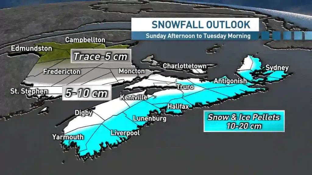
10–20 cm Snowfall Expected, Heaviest Near Coastline and Northeast
Most of Nova Scotia is expected to receive between 10 and 20 centimetres of snow from this system. Areas in the northwest are likely to see amounts closer to 10 centimetres, while heavier totals are expected along the Atlantic coastline and across northeastern regions.
In addition to the initial snowfall, onshore flurries are expected to continue in parts of the northeast, including Cape Breton and the Northumberland Shore, through Monday night and into Tuesday morning. This could push localized totals higher in those regions.
The snow itself will be wetter and heavier than typical mid-winter powder, making it more difficult to shovel and increasing the risk of slushy, compacted road conditions.
Rain and Ice Pellets Could Mix in Along Coastal Areas
Not all areas will see pure snowfall. Regions closer to the Atlantic coastline may experience periods of mixed precipitation on Monday, including ice pellets and rain. The greatest chance of this mix is expected in southwestern Nova Scotia and along the Eastern Shore.
This variation in precipitation type could create uneven and unpredictable road conditions, with surfaces shifting between slushy, icy, and snow-covered depending on location and time of day.
Strong Winds up to 80 km/h to Create Blowing and Drifting Snow
As the snow moves in, winds will also intensify. Northeasterly winds are expected to gust between 50 and 70 km/h across most of the province throughout Monday. These winds will contribute to blowing and drifting snow, especially in open and exposed areas.
Stronger gusts are forecast for parts of Antigonish, Guysborough, and Cape Breton, where winds could reach 70 to 80 km/h Monday night into Tuesday as the system begins to pull away.
These wind conditions will not only reduce visibility but could also worsen travel conditions even after snowfall begins to ease.
Monday Commutes Likely to Be Impacted Across the Province
The timing of the storm is a major concern. Most of Nova Scotia is expected to face a snow-covered morning commute on Monday, with poor road conditions and reduced visibility likely across multiple regions.
Conditions may not improve significantly throughout the day. Forecast guidance suggests that additional moderate snowfall is likely to continue into Monday afternoon and evening, particularly along the Atlantic coastline, the Northumberland Shore, and Cape Breton.
This means both the morning and evening commutes could be affected, increasing the likelihood of delays, slower traffic, and disruptions throughout the day.
For the latest weather updates and alerts, residents can check official forecasts from Environment and Climate Change Canada.
Forecast Models Show Uncertainty for Monday Afternoon Snow
Weather models have struggled with this system, particularly regarding its track and intensity during Monday afternoon and evening. The center of the system is expected to pass south of Nova Scotia, and small shifts in its position could influence snowfall amounts and duration.
After fluctuating over recent days, the latest projections suggest the system will remain close enough to bring continued moderate snowfall across much of the province through Monday afternoon. However, some variability remains, and localized differences in snowfall could still occur.
Snow Tapers West to East, But Flurries Linger into Tuesday
Snowfall is expected to gradually taper off from west to east Monday evening and overnight. However, the story doesn’t end there. Onshore flurries are forecast to persist in northeastern areas, including Cape Breton and the Northumberland Shore, through the night and into Tuesday morning.
This extended activity means some regions will deal with snow and wind impacts for nearly two full days, making this a prolonged weather event rather than a short-lived storm.
Parking Ban and Ferry Disruptions Announced Ahead of Storm
Authorities are already preparing for the storm’s impact. Halifax Regional Municipality has announced an overnight winter parking ban from 1 a.m. to 6 a.m. Monday in both Central and Non-Central zones to allow snow-clearing operations to proceed efficiently.
Marine transportation is also expected to be affected. Marine Atlantic has warned of potential schedule disruptions for sailings between North Sydney and Port aux Basques from 11:15 p.m. Monday through 11:30 p.m. Tuesday.
Additionally, Bay Ferries has cancelled the Fundy Rose’s 9 a.m. Saint John departure and 4 p.m. Digby departure for Monday. Travelers are advised to monitor updates directly from operators such as Marine Atlantic before making travel plans.
Spring Arrival Meets Winter Reality in Nova Scotia
While the calendar marks the beginning of spring, Nova Scotia’s weather is delivering a very different message. Late-season snowstorms are not unusual in the region, and this system highlights how winter conditions can persist well into March.
With heavy, wet snow, strong winds, and a prolonged timeline, this storm is expected to disrupt travel, challenge cleanup efforts, and delay the seasonal transition many were hoping for. Residents are encouraged to stay updated, plan ahead, and prepare for changing conditions as the week begins.
You may also like: Quebec City weather: 13-hour snowfall and -8C cold snap alert.
Make Swikblog your go-to source on Google for reliable updates, smart insights, and daily trends.