Calgary’s weather outlook turned sharply more serious on Sunday after a snowfall warning signalled that the city could be dealing with a messy and disruptive late-winter blast before the new week begins. After a relatively mild start that could bring rain ahead of the main system, conditions are expected to deteriorate through the day as colder air pushes in, changing precipitation over to snow and setting up what could become a difficult stretch for drivers, pedestrians and anyone trying to get around by Sunday evening.
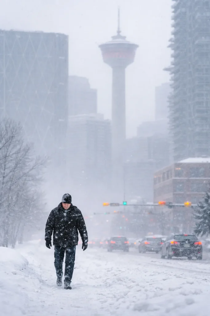
The biggest headline is the projected accumulation. Forecasters warned that Calgary could see 10 to 20 centimetres of snow, with the heaviest burst expected during the afternoon and evening. That timing matters because it raises the risk of rapidly changing road conditions at a point in the day when many people are still travelling, finishing weekend plans or preparing for the Monday morning commute. Snow that intensifies late in the day can quickly turn ordinary streets, neighbourhood routes and major commuter corridors into slow-moving, slippery trouble spots.
According to the latest official Calgary forecast from Environment and Climate Change Canada, snowfall is expected to taper off early Monday morning, but the impact may linger well beyond the end of the storm itself. Fresh accumulation overnight often leaves behind packed snow, slick intersections, reduced lane visibility and icy walkways just as a new workweek begins. Even if snowfall rates ease before sunrise, many Calgarians could still wake up to a slower and more hazardous trip into work or school.
Key forecast details for Calgary: snowfall totals of 10 to 20 cm, heaviest snow in the afternoon and evening, reduced visibility at times, and a sharp temperature drop with an overnight low near -5 C.
One of the more striking parts of this weather setup is how quickly the day may shift. Calgary could start with increasing cloud cover and even some rain before the system flips over to snow later in the day. That kind of transition can catch people off guard because streets may initially look wet and manageable, only to become slushy and then snow-covered within a short window. Once temperatures slide and winds strengthen, the city can go from spring-like inconvenience to full winter navigation problems very quickly.
The temperature swing is another reason this warning stands out. Conditions may climb into the double digits earlier in the day, giving the impression that the city is avoiding a major winter hit. But that warmer reading is not expected to last. Winds are forecast to pick up through the late morning and early afternoon, and colder air will drag temperatures down toward an overnight low of -5 C. That kind of drop can turn untreated surfaces slick fast, especially where daytime moisture remains on roads, parking lots, sidewalks and overpasses.
For drivers, the warning is less about a dramatic single moment and more about compounding hazards. Snow accumulation, falling visibility, shifting temperatures and gustier conditions can work together to create stop-and-start traffic, longer braking distances and more stressful commuting conditions. Roads and walkways are expected to become difficult to navigate as snow piles up, and visibility may be reduced at times, particularly during the heavier bands later Sunday. Anyone heading across the city after midday may find that travel takes much longer than expected.
Pedestrians and transit users may also feel the effects. Bus stops, station access points and neighbourhood sidewalks can become uneven and slippery during fast-accumulating snow, while wet surfaces that refreeze overnight often remain hazardous into the next morning. That means Monday’s first commute may be just as important to watch as Sunday’s main storm window. Even if the snowfall begins to fade by early Monday, leftover slush, icy patches and uncleared walkways could still cause delays across the city.
Storm timing puts Monday morning in focus
The forecast window is especially notable because the heaviest snow is expected late enough on Sunday to leave fresh accumulation in place overnight. That creates a higher chance that Calgary’s Monday morning routine begins with snow-covered side streets, slower transit movement and drivers needing extra time just to get out of residential areas. Plows and crews can help, but when a storm arrives in the second half of the day and continues into the night, the city often feels the full effect during the next morning rush.
Calgary’s weather story changed fast
What makes this setup so attention-grabbing is that it combines two very different weather messages in one day. Early mild temperatures and the chance of rain can make the city feel briefly removed from winter, only for the pattern to reverse with falling temperatures, stronger winds and steady snowfall. In practical terms, that means Calgarians may need to rethink plans quickly, dress for changing conditions rather than the midday temperature alone, and allow much more flexibility for evening and Monday travel.
For now, the main takeaway is simple: Calgary is staring at a weather turn that could deliver up to 20 centimetres of snow in a relatively short period, with the most disruptive conditions expected Sunday afternoon and evening and some of the biggest practical headaches likely to show up on Monday morning. In a city where March weather can swing wildly, this is the kind of alert that deserves attention because the change from mild and wet to cold and snow-covered may happen faster than many people expect.
Make Swikblog your go-to source on Google for reliable updates, smart insights, and daily trends.