A tornado emergency in Enid, Oklahoma, turned a severe-weather night into a major breaking news event after powerful storms swept across northern Oklahoma, causing damage, triggering rescue operations and producing dramatic footage of two tornadoes appearing to merge near Braman.
The storms developed Thursday evening as warnings expanded across Garfield, Kay and Grant counties. By late evening, the most serious threat focused on southeast Enid, where officials warned residents of a life-threatening tornado situation and urged people to take shelter immediately.
The National Weather Service describes a tornado emergency as its highest-level tornado alert, used when there is a severe threat to human life and catastrophic damage from a confirmed or clearly detected damaging tornado. Residents are advised to move to the safest shelter available without delay. National Weather Service tornado safety guidance
Enid tornado emergency brings damage reports and rescue response
The Garfield County Sheriff’s Office said search and rescue crews were launched after reports that people were trapped under debris in the Enid area. Officials indicated those affected were believed to be able to communicate, but emergency teams were still working through the early stages of extraction.
Authorities asked the public to avoid southeast Enid so first responders could reach damaged areas. Resources were also reported to be coming from nearby counties, including Logan and Kingfisher, as emergency teams worked to assess the scene.
Earlier warnings placed Enid, Waukomis, Breckenridge, Fairmont, North Enid and Vance Air Force Base in the path of dangerous storms. Local storm coverage reported structures hit as a large tornado moved near Vance Air Force Base, one of the most closely watched locations during the outbreak.
The warning language was especially urgent. Officials warned that flying debris could be deadly for anyone without shelter, mobile homes could be destroyed, and considerable damage to homes, businesses and vehicles was likely. The alert also warned that complete destruction was possible in the hardest-hit areas.
Severe thunderstorm warnings added to the danger across northern Oklahoma. Kay County and parts of Grant County faced threats including ping-pong to golf ball sized hail and wind gusts near 60 mph. Communities including Ponca City, Blackwell, Tonkawa, Newkirk, Kaw City, Braman, Lamont and Kaw Lake were among the areas repeatedly mentioned in warnings.
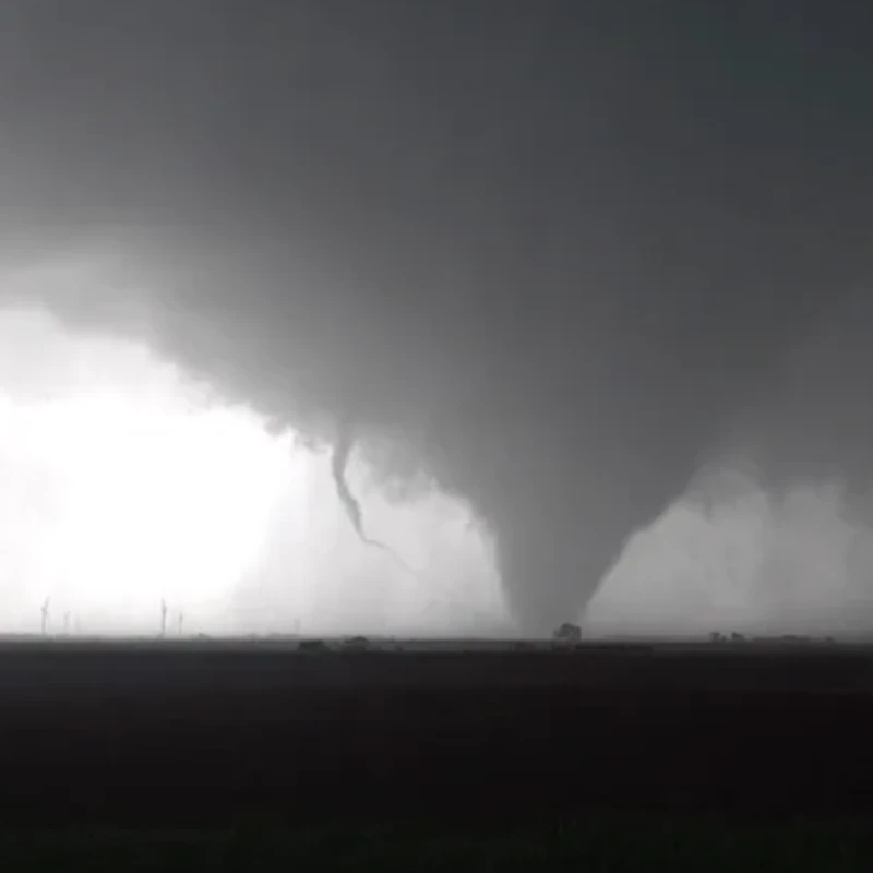
Two tornadoes near Braman draw national attention
One of the most striking moments came near Braman, Oklahoma, where storm trackers captured two tornadoes rotating close together before appearing to combine. The footage quickly fueled online searches for Enid, Braman and Oklahoma tornado updates as viewers followed live coverage and warning maps.
Braman and nearby areas in Kay County were under tornado warnings earlier in the evening, with storms described as extremely dangerous. Newkirk, Peckham and Blackwell Lake were also listed in warning areas as tornado-producing storms tracked near the Oklahoma-Kansas border.
Interstate 35 near the Oklahoma-Kansas line was reportedly affected as tornadic storms moved through the region. Road closures and damage reports added urgency for residents trying to understand the storm path and for emergency crews responding across multiple counties.
While the rare visual of two tornadoes merging drew attention, the larger concern remained the impact on people in the storm path. Tornadoes at night are especially dangerous because they are harder to see, warnings can be missed, and residents may have only minutes to reach shelter.
Why northern Oklahoma was at risk
The severe weather setup had been closely monitored before storms intensified. Forecasts highlighted northern and north-central Oklahoma as areas with elevated tornado potential, including Enid, Ponca City, Stillwater and Bartlesville.
The threat was not limited to tornadoes. Forecasters also warned of very large hail, damaging wind gusts and storms capable of organizing quickly. As the evening progressed, supercells developed near northern Oklahoma and moved through communities that had already been placed under tornado watches and warnings.
Late April is a historically active period for severe weather in the central United States. Warm, moist air from the south often collides with stronger upper-level winds and frontal boundaries, creating conditions that can support rotating thunderstorms. When those ingredients overlap, storms can intensify rapidly and produce tornadoes with little margin for error.
The Oklahoma outbreak also came during a broader Plains severe-weather pattern, with additional storm risks expected in parts of Oklahoma and surrounding states. That broader setup kept meteorologists focused not only on Thursday night’s damage, but also on the potential for more severe weather in the days ahead.
For residents in affected areas, officials continue to stress basic tornado safety: move to a basement, storm shelter or small interior room on the lowest floor; stay away from windows; protect your head; and avoid driving into storm-damaged areas after the threat passes.
Damage assessments are expected to continue as daylight gives emergency crews a clearer view of the tornado path. For now, Enid remains at the center of the story because of the tornado emergency, rescue operations and the rare Braman tornado interaction that pushed Oklahoma’s severe weather outbreak into national attention.
Related reading: Oklahoma severe weather updates and tornado safety coverage
You may like: Diljit Dosanjh Canada tour $1800 ticket and Punjabi music global growth explained
Make Swikblog your go-to source on Google for reliable updates, smart insights, and daily trends.