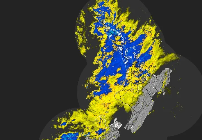
Northland is facing one of the most dangerous weather events seen in New Zealand this year, with a red heavy rain warning issued as forecasters warn of up to 280mm of rain, possible thunderstorms, severe flooding and slips. What began as a major storm threat has now escalated into a nationwide weather emergency, with 26 severe weather warnings and watches stretching from the top of the North Island to southern Canterbury.
The most serious alert is focused on Northland east of Kaikohe, from Doubtless Bay to Whangārei, where the red warning runs for 32 hours from 8pm Wednesday, March 25, until 4am Friday, March 27. Forecasts show 230mm to 280mm of rain could fall in the area, with peak rates starting at 15mm to 25mm an hour before rising sharply to 25mm to 40mm an hour from Thursday afternoon through early Friday morning. Thunderstorms are also possible, raising fears that already vulnerable communities could be hit by fast-moving, dangerous downpours on top of widespread heavy rain.
Red Warning Puts Northland at the Centre of a National Storm Crisis
A red warning is the most serious alert issued by MetService, and it signals a genuine threat to life from dangerous river conditions, major flooding and slips. In Northland, that warning carries extra weight because the same region was battered by January flooding, leaving some homes, roads and hillsides highly exposed if another major weather event hits. Local authorities are already urging residents in previously affected areas to make decisions early rather than waiting for conditions to worsen overnight.
Whangārei District Council has specifically advised people in Whangaruru North and South whose homes were impacted by flooding and landslips during the January event to leave if they do not feel safe. Residents have been told to head to family, friends or local marae if needed. The council also warned there should be nobody staying in red- or yellow-stickered buildings from the previous storm response, and urged people to restrict all non-essential travel due to the increased risk of flooding and landslides.
Storm Threat Extends Far Beyond Northland
This is not a one-region weather story. Orange heavy rain warnings are in place across large parts of the upper and central North Island, while more warnings and watches cover parts of the South Island as well. Areas under orange heavy rain warnings include the rest of Northland not under the red warning, Great Barrier Island, Auckland from Whangaparāoa northwards, the Coromandel Peninsula, the Hunua Range, Bay of Plenty west of Whakatāne, Tasman northwest of Motueka, and the Richmond and Bryant ranges including Rai Valley.
Several of those areas face a high chance of being upgraded. Coromandel could see 150mm to 200mm of rain, with up to 280mm possible around the ranges. Bay of Plenty west of Whakatāne is forecast to receive 200mm to 250mm, while parts of Tasman could see 180mm to 250mm. Heavy rain watches are also in force for Auckland south of Whangaparāoa, Waikato and Taupō, Taranaki Maunga, more of Tasman, inland Marlborough, the ranges of Westland, North Otago and parts of Canterbury south of Timaru.
120km/h Winds, Large Waves and Travel Disruption Add to the Danger
The rain is only part of the story. Northland and Auckland are also under orange strong wind warnings, with severe gale east to northeast gusts of up to 120km/h expected in exposed areas. Those winds could damage trees, powerlines and unsecured structures, while also making driving especially dangerous for high-sided vehicles and motorcycles. Strong wind watches have also been issued for Coromandel and Waikato, Taupō, Taumarunui, Taihape, Whanganui, South and Central Taranaki, and Banks Peninsula.
Authorities are also watching the Auckland Harbour Bridge closely. NZTA has warned that high winds may lead to lane closures or short periods of full closure if conditions become unsafe. Drivers of high-sided vehicles and motorcyclists are being advised to avoid the bridge and use the western ring route on State Highways 16 and 18 instead. Elsewhere, SH2 through Waioweka Gorge may also be closed at short notice if weather conditions deteriorate.
On top of the rain and wind, large waves are possible for eastern Northland and along both western and eastern coastlines of the South Island, adding another layer of coastal risk to an already volatile forecast.
Power Cuts Begin as Emergency Teams Move Into Position
The impact is already being felt. Power outages have been reported across Northland, with hundreds and later nearly 2000 homes and businesses left without electricity as the storm system moved in. Areas affected have included Oākura, Matapouri, Tutukaka, Aranga, Waipoua Kauri Forest, Mamaranui and Omamari, while separate outages were also reported in places stretching from Cape Reinga to Te Kao and from Ōmanaia to Waimamaku.
Emergency agencies are preparing for conditions to worsen. Fire and Emergency New Zealand has deployed 29 specialist firefighters with water rescue and urban search and rescue skills to Whangārei and Auckland ahead of the most dangerous phase of the storm. Another 16 specialist firefighters are ready to be sent to Coromandel and western Bay of Plenty depending on risk assessments. Officials say these teams are being pre-positioned to support volunteer brigades and help respond quickly if communities are cut off or flooding escalates.
Grab Bags, Marae Support and Evacuation Warnings
Northland Civil Defence has been urging residents to prepare grab bags, make evacuation plans, move vehicles and valuables away from flood-prone areas, bring pets inside, move stock from low-lying paddocks, and have essential supplies ready in case roads close or power is lost. A key warning from officials is that people may not have much time if intense downpours trigger land instability, and in some situations mobile alerts may not be sent in time.
Support locations are also being opened. Ngātiwai Trust Board said several Northland marae are available for whānau needing a safe place, including Mōkau Marae, Oākura Marae, Ngaiotonga Marae, Ngunguru Marae and Ōtetao Marae. That reflects just how seriously communities are treating the storm threat after the damage seen earlier this year.
What Happens Next
The next 24 to 48 hours are critical. Northland remains the highest-risk zone, but Auckland, Coromandel, Bay of Plenty and parts of the South Island are also on alert as the subtropical low pushes south. For live forecasts and warning updates, readers can track MetService warning updates. Road and bridge disruption information is also available through NZTA traffic alerts.
The main message from emergency authorities is simple: do not treat this as routine bad weather. With a red warning, flood risk, landslides, power cuts, possible evacuations and transport disruption all in play at once, this storm has the potential to turn dangerous very quickly.
You may also like: Graham Carey’s partner dies after cancer battle at 36
Make Swikblog your go-to source on Google for reliable updates, smart insights, and daily trends.