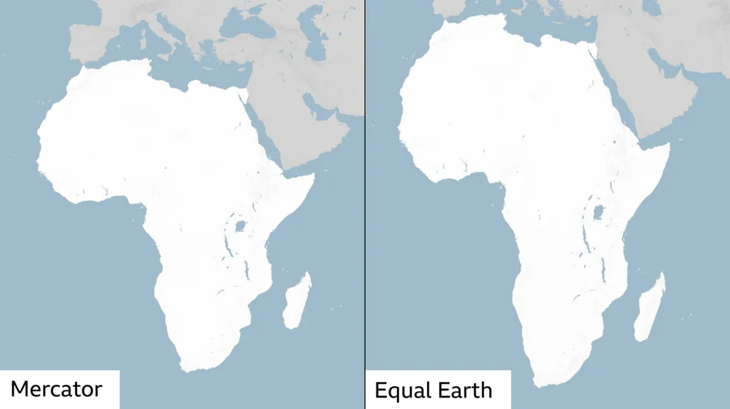

UNITED NATIONS — The UN General Assembly has backed a push for a world map that represents Africa closer to its true relative size, putting the Equal Earth projection at the centre of a global debate over how geography is shown in classrooms, institutions and everyday maps.
NEW: 🇺🇳 UN votes 164-1 to ditch the Mercator projection in favor of the “Equal Earth” map,
— Megatron (@Megatron_ron) September 5, 2026
The US was the only country who voted against
The dark blue shows the real size of the countries in the world pic.twitter.com/Y73Fy96QCI
The measure passed with 164 countries voting in favour. The United States cast the only vote against, while Estonia, Georgia, Lithuania, Moldova, Serbia and Ukraine abstained. The resolution is non-binding, so it does not immediately replace existing maps or ban the centuries-old Mercator projection.
What changes is the emphasis: supporters want maps used for general representation to stop making Africa and other equatorial regions look disproportionately small compared with northern land masses.
What did the UN vote actually change?
The initiative, spearheaded by Togo and backed by African Union members, promotes the Equal Earth projection as a better option when the purpose of a map is to compare the relative areas of countries and continents.
That distinction matters. The vote does not create a legally mandatory world map. Governments, schools, publishers, media organisations and technology companies can still decide which projection is appropriate for their needs.
The African Union’s 54 member states had already adopted Equal Earth earlier in 2026, saying it more accurately represents the sizes of continents, particularly Africa.
Why does Africa look bigger on the Equal Earth map?
Africa is not being enlarged. The difference comes from correcting one of the most obvious effects of the Mercator projection.
Mercator was created by Flemish cartographer Gerardus Mercator in 1569 and became valuable for navigation because it preserves directions and angles. But turning a globe into a flat rectangular map comes with a major trade-off: areas become increasingly exaggerated toward the poles.
That is why Greenland can appear almost comparable with Africa on a Mercator map. In reality, Africa covers about 30.4 million square kilometres and is roughly 14 times larger than Greenland.
The #CorrectTheMap campaign has offered another striking comparison: the United States, China, India, Japan, Mexico and much of Europe could fit inside Africa with land remaining.
Equal Earth vs Mercator: What is the difference?
Equal Earth, introduced by cartographers in 2018, is an equal-area projection. It preserves the relative surface areas of different parts of the world while keeping continental shapes broadly recognisable.
As a result, Africa, South America and parts of Asia appear substantially larger relative to Greenland, Europe and northern North America than they do on Mercator.
Equal Earth is not a perfect representation of the globe. No flat map can simultaneously preserve area, shape, distance and direction without distortion. The important difference is that Equal Earth prioritises accurate relative area.
Why did African countries push for a new map?
Supporters argue that the issue goes beyond cartography. Maps are used in schools, government documents, news reports and international institutions, meaning their visual proportions can influence how people perceive different regions.
Togolese Foreign Minister Robert Dussey has argued that maps shape education and collective perceptions. Campaign groups including Africa No Filter have similarly described Africa’s representation as a narrative issue as well as a geographical one.
The campaign comes amid a wider effort to strengthen Africa’s representation in international decision-making, also reflected in debates surrounding Africa’s expanding role in the G20.
Why did the United States vote against it?
The U.S. was alone in opposing the measure. American representative Yaryna Ferencevych criticised the General Assembly for spending time on a historical map projection instead of what Washington considers more pressing issues involving international peace, prosperity and relations between nations.
The U.S. objection therefore focused largely on the resolution’s purpose and political framing rather than disputing the mathematical area distortion produced by Mercator.
Trump Venezuela Oil Deal: What It Could Mean for Gas Prices
Bolivia Military Base Explosion: Death Toll Rises as Dozens Injured in Viacha
France is already moving away from Mercator
France supported the resolution and announced that its foreign ministry would move away from Mercator for relevant diplomatic cartography.
The French Foreign Ministry said map projections should be selected according to their purpose and highlighted how Mercator gives disproportionate visual prominence to some northern countries.
Will Google Maps, GPS and school maps now change?
Not automatically. The UN vote does not order Google or other mapping services to adopt Equal Earth, and there is currently no universal deadline for changing school maps.
Togo intends to update its own school geography materials and supporters plan to encourage governments, educational institutions, publishers and technology companies to consider Equal Earth. Future discussions are also expected to involve businesses working with mapping, GPS and location technologies.
Questions over how digital maps represent geography are already receiving greater attention, including separate controversies involving Google Maps and geographic naming changes.
Is the Mercator map being banned?
No. Mercator remains particularly useful for navigation, where preserving direction is more important than comparing land area.
The significance of the 164-1 vote is instead about which map people see when they are learning what the world looks like. If governments, schools and publishers follow the UN-backed initiative, Africa will not suddenly become bigger on the map — it will simply appear much closer to the enormous size it has always been.

Make Swikblog your go-to source on Google for reliable updates, smart insights, and daily trends.