Washington’s midweek weather setup is shaping into one of the most important travel stories in the Pacific Northwest this week. Wednesday has been flagged as a Pinpoint Alert Day as a moisture-rich storm pushes into the region, setting the stage for heavy mountain snow, periods of soaking rain in the lowlands, and wind strong enough to add another layer of disruption. For drivers planning to cross the Cascades, the timing could hardly be worse. The snow is expected to build from Tuesday evening and continue into Thursday, with the heaviest totals focused in the mountains and pass travel likely to become increasingly difficult as conditions deteriorate.
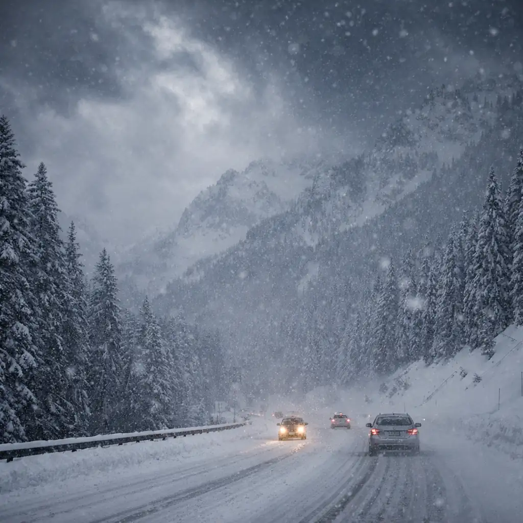
The headline risk is not subtle. Forecasts point to one to three feet of snow in the mountains over the core of the event, with travel concerns centered on major routes such as Snoqualmie Pass and other Cascade crossings. Even before the deepest totals pile up, snow-covered roads, changing visibility, chain requirements, and sudden slowdowns can quickly turn a routine drive into a long and stressful one. That is why this storm is attracting so much attention across Western Washington: it is not just about snowfall totals, but about the real possibility of widespread travel headaches during the middle of the week.
Planning more weather coverage for your readers? You can direct them to the latest updates on Swikblog for broader breaking-news coverage and follow-up reporting.
Why Wednesday stands out
Western Washington is expected to deal with several storm systems this week, but Wednesday stands out because the atmosphere may deliver the strongest overlap of moisture, snow production in the higher elevations, and messy travel conditions. In the mountains, the concern is straightforward: sustained snowfall over an extended period. In the lowlands, the picture shifts to rain, at times heavy, with gusty winds that could make commutes less predictable and create reduced visibility on exposed roadways.
That combination matters because the region often feels these storms in very different ways at the same time. Seattle and nearby lowland communities may be dealing with wet roads, standing water, and a breezy, raw day, while just a few thousand feet higher the Cascades are taking on truly significant snowfall. That contrast can create a false sense of security for travelers leaving lower elevations in ordinary rain and then running into winter driving conditions deeper into the passes.
Mountain snow could be measured in feet, not inches
The most eye-catching part of the forecast is the potential for several feet of accumulation in the mountains by the time the event winds down. That kind of setup is welcome news for higher-elevation snowpack, but it comes with obvious short-term tradeoffs for drivers, freight movement, and anyone trying to cross the state on a schedule. Roads can become slick quickly, tire traction becomes a bigger issue, and even brief bursts of heavier snowfall can sharply reduce visibility.
For Washington residents, this is the type of forecast that usually changes plans. Some travelers will move their trips earlier to avoid the worst of the storm window. Others may postpone entirely, especially if they are towing, carrying cargo, or driving routes that depend on pass conditions remaining stable. Ski-area traffic, commercial transport, and everyday cross-state travel can all feel the impact when mountain snow intensifies faster than expected.
Lowlands face a different set of problems
While the mountains collect snow, the lowlands are expected to lean wetter and milder. Rain could be heavy at times on Wednesday, and wind gusts above 30 mph are possible in parts of the region. That does not turn this into a classic lowland snow headline, but it does raise the risk of a slow, frustrating day on the roads. Wet pavement, ponding in poor-drainage spots, reduced visibility, and windy stretches can all combine to create difficult commuting conditions even outside the passes.
There is also the broader midweek rhythm to consider. Wednesday travel tends to bring work commutes, school traffic, delivery routes, and regional movement all at once. A storm hitting in that window naturally draws more attention because it lands when large numbers of people are already on the move. That is one reason weather alerts framed around travel often earn strong reader interest: people are not just curious, they are actively deciding whether to drive, delay, or reroute.
What drivers should watch most closely
The biggest variable is not whether snow will fall in the Cascades. It is how fast conditions worsen once the heavier part of the system arrives. Snow levels can fluctuate, bursts of precipitation can change road surfaces quickly, and visibility may drop with little warning. For anyone planning a mountain crossing, the most important factors are road restrictions, traction requirements, and real-time pass conditions rather than the temptation to rely only on a broad regional forecast.
That is why the smartest approach is to treat Wednesday as a day for flexibility. Early departures, delayed travel, or alternate scheduling may end up being the difference between a manageable trip and hours of weather-related frustration. For readers not planning to drive through the mountains, the story is still worth watching because the storm will shape the broader feel of the week across Western Washington, from rainy commutes to windy stretches and steadily changing conditions into late week.
The bottom line for Washington readers is simple: Wednesday looks like a high-impact weather day, especially for anyone with mountain travel plans. Heavy snow in the Cascades, rainy lowland conditions, and gusty winds make this more than just another wet Pacific Northwest forecast. It is the kind of setup that can disrupt plans quickly, and it deserves close attention before heading out.
For the latest official forecast and travel-focused updates, readers can monitor the National Weather Service Seattle/Tacoma forecast office as conditions evolve.
Make Swikblog your go-to source on Google for reliable updates, smart insights, and daily trends.