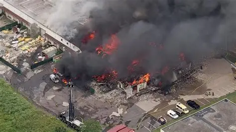
Hawaii is preparing for a dangerous round of severe weather as a powerful Kona storm moves toward the islands, bringing school closures, heavy flooding rain, damaging winds, and hazardous travel conditions through the weekend. Forecasters say the storm could deliver some of the strongest winds of the year along with widespread rainfall that may trigger flash flooding in multiple areas.
The severe weather system is expected to intensify beginning Friday, with the most significant impacts likely across Kauai, Oahu, and parts of Maui County. As conditions worsen, officials are already announcing school closures and urging residents to prepare for rapidly changing weather conditions.
The storm is expected to bring several hazards at once: flooding rain, powerful winds, thunderstorms, and even winter storm conditions on the highest summits of the Big Island. Because of the wide range of impacts, the event is shaping up to be one of the most disruptive weather systems Hawaii has seen in recent months.
School closures begin as dangerous weather approaches
One of the earliest signs of the storm’s seriousness is the growing list of school closures across the islands. School officials often make closure decisions when weather threats could affect transportation safety, power reliability, or campus operations.
Heavy rain combined with strong wind gusts can make bus routes dangerous and create flooding on major roadways. In many communities across Hawaii, roads pass through low-lying areas or steep terrain, where flash flooding can develop quickly during intense rainfall events.
Because the most dangerous conditions are expected overnight and into the morning hours, school administrators are acting cautiously to protect students, teachers, and families.
Heavy rainfall expected across multiple islands
The biggest concern for many residents will be the potential for significant rainfall totals. Forecasters say rainfall totals of 2 to 5 inches are possible overnight, particularly for Kauai and Oahu, where the first bands of heavy rain are expected to arrive.
As the storm strengthens on Friday, rainfall totals could increase dramatically. Some areas could receive 4 to 8 inches of rain during the day Friday, raising the risk of flash flooding, overflowing streams, and dangerous driving conditions.
Looking ahead through the weekend, rainfall totals could climb even higher. Meteorologists say some locations could see 10 to 15 inches of rain by the end of the weekend, especially in mauka areas and locations that typically receive higher rainfall during Kona storm events.
These rainfall levels could cause localized flooding, road closures, and possible landslides in vulnerable areas.
High Wind Warning issued with gusts up to 60 mph
In addition to heavy rain, strong winds are expected to intensify across the islands. South winds overnight are expected to remain around 10 to 20 mph, but conditions are forecast to change rapidly Friday morning.
Wind speeds could increase to 25 to 35 mph with gusts up to 60 mph, particularly in locations north and east of mountain ranges where winds can accelerate.
A High Wind Warning has been issued for Kauai County, Oahu, and the lower elevations of Maui County as the storm moves closer. These winds could be strong enough to knock down tree branches, damage structures, and cause scattered power outages.
A High Wind Watch is also in effect for the Big Island beginning Friday morning and continuing into Saturday night.
Big Island summits face winter storm conditions
While most of Hawaii prepares for flooding rain and strong winds, the highest elevations of the Big Island are expected to experience completely different conditions.
A Winter Storm Warning has been issued for the summits of Mauna Kea and Mauna Loa. Forecasters say the mountains could receive 12 to 18 inches of snow along with extremely powerful wind gusts that may reach 110 mph.
These conditions could create dangerous travel and visibility issues at the highest elevations.
Severe weather likely to continue through the weekend
According to forecasters, the most intense period of the storm will occur from Friday through Saturday as the system spreads across the state.
Strong thunderstorms and heavy rain will continue to move across multiple islands, while Kona winds bring additional wind threats to windward mountain slopes.
Even after the worst of the storm passes, wet weather is expected to linger. Rain could continue across parts of the islands through Tuesday of next week, prolonging the risk of flooding and travel disruptions.
Surf conditions also becoming hazardous
In addition to the storm impacts on land, ocean conditions around the islands are also expected to change as the weather system moves through the region.
Forecast surf heights include:
- North shores: 2 to 5 feet
- West shores: 3 to 6 feet
- South shores: 4 to 8 feet
- East shores: 1 to 3 feet
As winds increase and weather conditions deteriorate, surf conditions could become dangerous for swimmers and boaters.
Residents urged to stay prepared
Officials are encouraging residents to monitor weather alerts and prepare for potential disruptions. Flooding, power outages, and hazardous travel conditions could occur as the storm intensifies.
Families should stay updated on school closure announcements and emergency advisories as conditions change. Travelers and commuters are also advised to avoid unnecessary trips during the worst weather periods.
The latest forecast updates and weather warnings can be monitored through the National Weather Service Honolulu forecast office and official Hawaii emergency updates at the Hawaii Emergency Management Agency.
As Hawaii faces flooding rain, damaging winds, and even winter storm conditions at high elevations, residents across the islands are being urged to remain cautious and prepared while the powerful Kona storm moves through the region.
You may also like: Colorado Winds Trigger Xcel Power Outage as Mountain Wave Hits Front Range
Make Swikblog your go-to source on Google for reliable updates, smart insights, and daily trends.