Far North Queensland is facing a dangerous cyclone emergency as Severe Tropical Cyclone Narelle approaches the coast as a category five system, with authorities warning of destructive winds, flash flooding and significant damage as the storm moves toward landfall on Friday morning. The latest updates indicate Narelle remains an extremely powerful system, and communities across Cape York are being told to brace for a severe impact as conditions rapidly deteriorate.
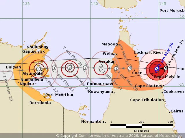
The Bureau of Meteorology’s latest forecast says Tropical Cyclone Narelle is expected to cross the Far North Queensland coast between Lockhart River and Cape Melville later on Friday morning. The cyclone remains a category five system, carrying sustained winds of 205 kilometres an hour and moving westwards at 19 kilometres an hour. It was estimated to be 175 kilometres east of Coen in the most recent overnight update, underscoring how close the system is to the Queensland coast.
Narelle remains a category five threat as landfall nears
The latest 2am Bureau of Meteorology update confirmed that Narelle has maintained category five intensity as it heads toward the coast. That makes it one of the most dangerous weather systems to threaten Far North Queensland this season. While the BOM has indicated the cyclone may have peaked in intensity and could weaken to a category two after moving over land, the immediate danger remains severe as the system crosses the coast during Friday morning.
That distinction matters. Even if weakening begins after landfall, the crossing itself is expected to bring the cyclone’s most destructive conditions, including wind gusts above 250 km/h near the centre, widespread damaging winds, and heavy rainfall capable of triggering flash flooding across the peninsula. In short, the downgrade risk later does not reduce the immediate danger facing the communities in the cyclone’s path right now.
Warning zones across Far North Queensland and the Northern Territory
The Bureau has issued a warning zone in Queensland between Lockhart River and Cape Flattery, and another between Mapoon and Pormpuraaw, including Coen, Weipa and Aurukun. These are the areas expected to face the strongest direct impacts as the cyclone crosses the Cape York Peninsula. A watch zone is also in place for parts of the Northern Territory, stretching from Nhulunbuy to Port McArthur, including Borroloola, Numbulwar, Alyangula and Ngukurr, as the system is expected to track westward after affecting Queensland.
At the same time, warnings have been cancelled for the area between Cape Tribulation and Cape Flattery, including Cooktown, reflecting a slight easing in risk for communities further south. Still, officials have made clear that the danger remains concentrated across Cape York and nearby communities, where the cyclone’s track and wind field continue to pose a major threat.
Residents warned of very destructive winds and flash flooding
The latest hazard advice from the Bureau lays out a serious and multi-layered threat. Very destructive wind gusts in excess of 250 km/h are possible near the centre of Severe Tropical Cyclone Narelle as it crosses the Cape York Peninsula coast on Friday morning. Destructive wind gusts to 160 km/h are likely from south of Lockhart River to north of Cape Flattery, and those destructive conditions are expected to persist near the centre of the cyclone as it moves inland during Friday.
Gales with damaging wind gusts to 120 km/h are also likely from Cape Flattery to north of Lockhart River. Those gale-force conditions are forecast to extend across Cape York Peninsula as the system travels inland, including areas between Mapoon and Pormpuraaw during Friday. This means the danger is not limited to a narrow coastal strip. Inland communities across the peninsula may also experience powerful winds capable of causing tree damage, roof loss, power outages and dangerous travel conditions.
Heavy rainfall is another critical threat. The Bureau has warned that rainfall associated with the cyclone may lead to flash flooding, with locally intense rainfall likely in an area of the peninsula bounded by Lockhart River, Cape Flattery, Pormpuraaw and Weipa during Friday. Earlier reports also noted rainfall totals of between 40 and 50mm had already been recorded over several hours between Coen and Lockhart River, showing that the rain threat was building even before the storm’s core reached the coast.
Premier David Crisafulli warns damage will be significant
Queensland Premier David Crisafulli has issued a direct warning to residents ahead of landfall, saying the impact from Narelle is expected to be significant. In comments broadcast by ABC News, the premier said the cyclone was a very big system and made clear that the threat could not be sugarcoated. While the areas in the direct path may not be heavily populated, he stressed that the communities under threat still matter and are firmly in the firing line as the system closes in.
The premier also said the Queensland government has resources on the ground ready to respond as soon as conditions are safe enough for crews to move in. That response readiness will be important because some affected communities are remote, and post-cyclone recovery can be slowed by flooded roads, damaged infrastructure and communication outages.
ABC Emergency and official warning channels now critical
Residents in affected parts of Far North Queensland are being urged to stay updated through official emergency channels as conditions change. ABC Emergency is carrying regular updates and warning maps, while ABC Radio stations across the region are broadcasting emergency information for local communities. The coverage includes Cairns and surrounds on 801 AM and 106.7 FM, Cairns North on 95.5 FM, Coen on 105.9 FM, Cooktown on 105.7 FM, Lakeland on 106.1 FM, Laura on 106.1 FM, Mossman and surrounds including Daintree and Port Douglas on 639 AM, and Weipa on 1044 AM. ABC Far North is also available on Channel 211 through the VAST satellite service.
For live warnings, hazard maps and cyclone track updates, residents are also being directed to the ABC Emergency website and the Bureau of Meteorology. With Narelle now nearing landfall as a category five system, the message across Far North Queensland is urgent and clear: stay sheltered, avoid unnecessary travel, monitor official alerts closely, and prepare for destructive winds, heavy rainfall and major disruption through Friday.
Make Swikblog your go-to source on Google for reliable updates, smart insights, and daily trends.