The western United States is heading for a dramatic weather shift as Pacific storms prepare to snap a record-breaking heat wave that has shattered thousands of temperature records. After days of unusually intense March heat, cooler air, spotty rain, thunderstorms, and even mountain snow are expected to sweep across the region next week. However, despite the incoming storms, meaningful drought relief and wildfire risk reduction may remain limited.
This recent heat wave has been historic in both scale and intensity. According to AccuWeather, nearly 700 monthly record highs and more than 2,000 daily record highs have already been broken across the West. Temperatures surged far beyond seasonal norms, with conditions resembling peak summer rather than early spring.
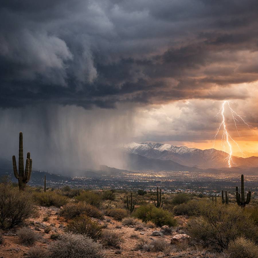
Cities across the Southwest experienced extreme heat. Phoenix recorded three consecutive days at or above 105°F between March 19 and March 21. Palm Springs reached 108°F, while Yuma climbed to 109°F. These temperatures are typically seen in June or July, making their occurrence in March particularly unusual and concerning.
Heat Shifts Before Breaking Down
Although some areas have already passed their peak temperatures, the heat has not fully subsided. It has been shifting geographically, moving from the interior Southwest into parts of the Plains. Several locations across the Great Plains recorded daily record highs earlier this week, and additional hot days are expected through the weekend.
While a brief push of cooler air may dip southward temporarily, another surge of heat is forecast to rebuild before the full pattern change begins. This prolonged warmth has significantly increased fire danger across the interior West and High Plains.
Three Pacific Storms to Drive Major Weather Change
The transition away from extreme heat will be driven by a series of three Pacific storms arriving between Sunday and Wednesday. Rather than one powerful system, multiple disturbances will gradually shift the pattern, bringing cooler air and limited precipitation.
The first storm, arriving Sunday into Monday, will be relatively weak but important. It is expected to pull moisture northward from the subtropical Pacific across Mexico and into Arizona, New Mexico, Utah, and Colorado. This setup may resemble the early stages of the North American monsoon, although it is far too early in the season for a sustained monsoon pattern to develop.
This initial system could trigger spotty thunderstorms, particularly across the Four Corners region. However, these storms may bring more risks than benefits. Lightning strikes and gusty winds could ignite new wildfires, especially in areas where rainfall is minimal. In some locations, storms may produce blowing dust instead of rain, reducing visibility and creating hazardous conditions.
Second Storm Brings Cooling and Limited Rain
The second storm, expected Tuesday into Tuesday night, will have a more noticeable impact on temperatures across the West. Rain is forecast for California, northern Nevada, southern Oregon, and Idaho. In cities like San Francisco, this system could produce the most significant rainfall since mid-February, with a few tenths of an inch possible.
However, uncertainty remains regarding how far south steady rainfall will reach. Much of Southern California and large portions of Nevada are likely to see only sporadic showers or remain mostly dry. This limits the storm’s ability to provide meaningful drought relief.
The most significant impact of this system will be the drop in temperatures. Sacramento, which is expected to see highs in the 80s over the weekend, will cool into the 70s on Monday and the 60s by Tuesday. Los Angeles will see temperatures fall from well into the 80s to near 70. Phoenix is forecast to drop into the low 80s by Tuesday and Wednesday, marking a sharp contrast from recent triple-digit heat.
Some high-elevation snow is also expected Tuesday night, though it will not match the intensity of earlier winter storms.
Third Storm Targets Northwest and Rockies
The third and strongest storm will arrive Wednesday, tracking into the Pacific Northwest before spreading inland. This system is expected to bring rain and mountain snow to Washington, Oregon, and Northern California, before extending into northern Nevada, Idaho, and the northern and central Rockies later in the week.
Higher elevations will likely see snowfall, providing some benefit to snowpack levels. However, the overall precipitation from all three storms combined is expected to remain limited, particularly across the Colorado River basin and desert regions.
Drought Relief Limited, Fire Risk Remains
Despite multiple storms affecting the region within a short period, total rainfall amounts are expected to be insufficient to significantly ease drought conditions. The lack of widespread, soaking rain means water shortages and dry landscapes will persist across much of the West.
Wildfire concerns remain a major issue. The recent heat wave has intensified drying, and the incoming storms may not provide enough moisture to offset those effects. In fact, thunderstorms with lightning and gusty winds could increase fire ignition risks in certain areas.
Even as temperatures cool, fire danger may continue well into the typical spring greenup season. Experts continue to monitor conditions closely, with updates from the National Weather Service highlighting ongoing risks.
In the coming days, the western U.S. will transition from record-breaking heat to a more seasonable pattern. However, while Pacific storms will bring noticeable cooling and some precipitation, the overall impact may fall short of delivering the widespread relief that many regions urgently need.
Make Swikblog your go-to source on Google for reliable updates, smart insights, and daily trends.