Scientists are increasingly warning that 2026 could bring one of the strongest El Niño events seen in modern history, with some early climate models even drawing comparisons to the devastating 1877-78 Super El Niño that triggered famine and extreme weather across multiple continents.
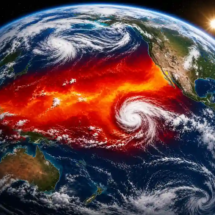
The growing concern comes after new forecast runs from the European Centre for Medium-Range Weather Forecasts (ECMWF) showed sea surface temperatures in the Niño 3.4 region potentially climbing close to 3 degrees Celsius above average later this year. If those projections continue strengthening through summer, meteorologists say the world could be heading toward a rare “Super El Niño.”
While El Niño is a naturally occurring climate pattern, an unusually powerful event can disrupt weather systems around the globe, influencing storms, droughts, rainfall, food production and global temperatures for months.
According to NOAA’s official ENSO monitoring outlook, El Niño conditions are expected to develop during 2026 and may continue into early 2027. The agency cautions that forecast confidence remains moderate because ocean-atmosphere interactions can still change rapidly during the spring and early summer transition period. NOAA continues to update its outlook through the ENSO Diagnostic Discussion.
Why the 1877 Super El Niño is being discussed again
The recent forecasts have revived discussion around the historic 1877-78 El Niño event, widely considered one of the deadliest climate disasters ever recorded. Historians and climate researchers estimate that more than 50 million people died globally during the famine and disease outbreaks linked to the extreme weather shifts caused by that event.
India, China, Brazil and several other regions suffered catastrophic crop failures after severe droughts and prolonged heat devastated agricultural production. Researchers studying the disaster later described it as one of the worst environmental calamities in at least the last 150 years.
However, scientists stress that the world today is vastly different from the late 19th century. During the 1870s, countries lacked modern irrigation systems, food transportation networks, accurate weather forecasting and emergency disaster response infrastructure. Colonial-era economic policies also worsened food shortages in some regions.
That means a modern Super El Niño would not automatically create a repeat of the 1877 famine disaster. But experts say the comparison still matters because it demonstrates how powerful climate disruptions can become when ocean temperatures rise to extreme levels.
The latest concern is amplified by the fact that global ocean temperatures are already running at unusually high levels. Scientists say that additional warming from a major El Niño could push certain regions into record-breaking heat territory during late 2026 and early 2027.
What scientists are watching in the Pacific Ocean
El Niño develops when trade winds weaken across the equatorial Pacific Ocean, allowing warm water to spread eastward toward South America. As ocean temperatures rise, the atmosphere responds by shifting rainfall and pressure patterns across large parts of the globe.
Climate researchers are currently focused on several key indicators:
- Rapid warming in the Niño 3.4 region of the Pacific
- Subsurface heat building beneath the ocean surface
- Westerly wind bursts developing near the equator
- Atmospheric pressure changes linked to ENSO cycles
University at Albany atmospheric scientist Paul Roundy recently noted that the newest ECMWF projections are moving “solidly into record territory,” adding that additional ocean momentum over recent weeks may increase the likelihood of a major event later this year.
Forecasters are especially watching for stronger westerly wind events during the coming months because they can rapidly intensify El Niño conditions by transferring more heat across the Pacific basin.
Still, meteorologists caution that long-range seasonal models can fluctuate significantly. Some previous forecasts for extreme El Niño conditions have weakened later in the year as atmospheric patterns changed.
Potential global impacts if a Super El Niño develops
A strong El Niño can produce very different impacts depending on the region. Some areas may experience flooding and stronger storms, while others face severe drought and heat.
Possible impacts during a Super El Niño include:
- Extreme heat waves across parts of Asia, Europe and North America
- Weaker or more erratic monsoon rainfall in India
- Drought conditions in Australia and portions of Southeast Asia
- Flooding risks along parts of the Americas
- Crop stress affecting global food prices
- Coral bleaching from unusually warm ocean water
- Changes to hurricane and cyclone activity
For coastal communities and surfers, El Niño years can also bring more energetic Pacific storm patterns and larger swells in some regions. Swikblog recently covered unusual ocean-driven weather shifts and their impact on coastal conditions in its report on Pacific storms reshaping western U.S. weather patterns.
Economists are also monitoring the forecasts closely because extreme climate conditions can disrupt supply chains, agriculture, shipping and energy demand simultaneously. Even moderate crop losses across multiple countries can contribute to higher food inflation worldwide.
Despite the alarming headlines surrounding the “Super El Niño” discussion, scientists are not calling for panic. The event is still developing, and its final strength remains uncertain. But the increasing ocean warmth and evolving Pacific conditions are strong enough that governments, emergency agencies and agricultural sectors are beginning preparations months in advance.
The most important period may come later this year. If Pacific temperatures continue accelerating through summer and atmospheric conditions fully align with the ocean warming, confidence in a major El Niño event could rise sharply heading into late 2026.
Make Swikblog your go-to source on Google for reliable updates, smart insights, and daily trends.