
Typhoon Bavi is raising alarms across Taiwan, eastern China and Japan’s southern islands as a vast storm system moves through the western Pacific with winds near 200 km/h and the potential to bring dangerous rain, flooding and coastal impacts through the weekend. The storm’s size is what makes it especially concerning: forecasters say Bavi stretches around 1,000 km at its widest point, giving it the ability to affect areas far beyond its centre.
Taiwan is preparing for one of its most serious typhoon threats in years. The storm is expected to pass near northern Taiwan before heading toward China’s Fujian province, where landfall is forecast around Saturday evening. Authorities are watching the track closely because even a modest shift could change which communities face the worst wind, rain and storm surge.
The Taiwan Central Weather Administration continues to issue typhoon information as Bavi approaches, including updates on track, wind conditions and rainfall risk.
Why Taiwan is taking Bavi seriously
Bavi is not just another seasonal typhoon. Taiwan forecasters have described storms of this size as rare in recent years, and Bavi could become the largest storm by size to affect the island since 1987. It may also become Taiwan’s strongest typhoon threat since Kong-rey in 2024, a storm that killed three people.
The heaviest rain risk is focused on northern Taiwan, especially the mountain areas around Taipei, where rainfall totals could reach up to one metre. In steep terrain, that volume of rain can trigger landslides, flash flooding, river surges and road closures within hours.
Taiwan’s defence ministry has placed about 29,000 soldiers on standby for possible disaster response. Their role could include evacuation support, road clearance, flood assistance and delivery of supplies to communities cut off by the storm.
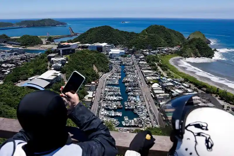
In Suao, a port town in northeastern Taiwan, fishing boats were moved into sheltered harbour space before conditions worsened. Residents collected sandbags, while farmers rushed to harvest rice before rainbands from the storm arrived. For coastal towns, early preparation is often the difference between manageable damage and severe losses once waves, surge and wind begin to build.
Local concerns are shaped by past storms that flooded streets and damaged boats. That history explains why officials and residents are acting before the worst weather arrives, even while conditions in some areas still appear calm.
China faces a second storm risk after deadly flooding
Bavi is also a major concern for China because it is arriving while parts of the country are still recovering from Typhoon Maysak. In Guangxi, officials said Maysak killed at least 39 people and left nine others missing after severe flooding earlier this week.
The remnants of Maysak also caused inland tornadoes and major flooding in Hubei province. In parts of Guangxi, rescue teams were still clearing wreckage, helping stranded residents and using drones to deliver supplies to communities that could not be reached easily by road.
That timing increases the risk from Bavi. When a second major storm follows soon after a deadly system, rivers may still be swollen, hillsides may already be unstable and emergency crews may be stretched. Even if Bavi weakens slightly before landfall, its rain field and storm surge could still create dangerous conditions in coastal and inland areas.
China’s eastern Fujian province is expected to be the key landfall zone under the current forecast. Fujian is highly exposed to typhoons because of its long coastline, dense coastal cities, ports, fishing communities and mountain areas that can amplify rainfall impacts.
Japan is already seeing travel disruption from the storm. Okinawa Prefecture has warned residents to stay alert for violent winds, flooding, landslides and storm surge. Japan Airlines cancelled 48 domestic flights and two international flights for Friday, affecting about 7,610 passengers. All Nippon Airways also announced cancellations mainly linked to Ishigaki and Miyako airports, with more disruption expected into Saturday.
Travellers moving through Taiwan, Okinawa or eastern China should check airline and airport updates before leaving for terminals. Storm-related cancellations can expand quickly when wind, visibility and airport ground operations become unsafe.
What makes Bavi dangerous beyond wind speed
Wind speed is only one part of Bavi’s threat. The storm has spent a long period over warm Pacific waters, allowing it to gather energy and moisture. That moisture is why rainfall, not only wind, may become the most damaging hazard for Taiwan and parts of China.
Large typhoons can keep producing dangerous weather even if their peak winds ease before landfall. Outer rainbands can dump heavy rain hundreds of kilometres from the centre, while coastal surge can push seawater into low-lying areas before the eye comes ashore.
Forecast experts have warned that Bavi may lose some wind intensity, but remain dangerous from Friday into Monday as it affects Taiwan and eastern China. The long impact window matters because repeated rainbands can worsen flooding over several days.
Read More:
- 730-pound great white shark Bella spotted in the Gulf of St. Lawrence
- K2 Airways cargo plane reported missing near Karachi
- Visit the Swikblog homepage for more latest news
The storm is also arriving during a period of growing concern about extreme weather in East Asia. Scientists have linked warmer oceans to the potential for stronger tropical cyclones, while El Niño conditions can influence regional temperatures and storm behaviour. Individual typhoons still depend on many atmospheric factors, but warmer seas can provide more fuel for powerful systems.
Emergency officials are urging residents to prepare before conditions deteriorate by securing outdoor belongings, keeping emergency supplies ready and monitoring official forecasts. Similar severe weather has recently affected other regions, including the rare May snowstorm that triggered weather alerts across Victoria and New South Wales, highlighting how rapidly changing conditions can disrupt travel, infrastructure and daily life.
For residents in affected areas, the safest approach is to prepare before conditions deteriorate. Secure outdoor objects, avoid coastal sightseeing, keep phones charged, prepare emergency supplies and follow local evacuation or shelter instructions. Mountain communities should be especially alert for landslides, while coastal residents should treat storm surge warnings seriously.
Bavi’s final path will determine where the worst damage occurs, but its size means the risk is not limited to the landfall point. Taiwan, Fujian and Okinawa all face several days of disruption from a storm capable of bringing flooding rain, dangerous winds and rough seas across a wide area.

Make Swikblog your go-to source on Google for reliable updates, smart insights, and daily trends.