Australia’s southeast has been thrown into an early winter shock after a powerful burst of polar air swept across Victoria, New South Wales, Tasmania and the ACT, bringing rare May snow, freezing winds, hail showers and some of the coldest temperatures recorded so far in 2026.
The cold outbreak arrived overnight after a sharp front moved in from the Southern Ocean, pulling Antarctic air across the southeastern states. By Thursday morning, alpine villages, high country roads and even some lower-elevation towns had turned white, creating scenes more commonly associated with the middle of winter than early May.
Victoria was one of the hardest-hit areas. Mt Baw Baw received about 15 centimetres of fresh snow overnight, covering roads, trees and buildings across the alpine village. Mt Buller also saw a strong early-season fall, with several centimetres settling across the resort and snow continuing through the morning in large flakes.
Falls Creek recorded overnight temperatures near -5.4°C, while Mt Hotham dropped below -5°C. Strong southwesterly winds made conditions feel far colder, with apparent temperatures in some exposed alpine areas plunging into the minus teens. Snow-cam images from the resorts showed chairlifts, rooftops and ski runs blanketed in fresh snow just weeks before the official ski season begins.
Rare May Snow Reaches Lower Towns
The most striking part of the event was not only the snow on the peaks, but how far down the cold air reached. Snowflakes were reported in parts of New South Wales including Cooma and Jindabyne, where snow at lake level is uncommon even during the winter months. Perisher and Thredbo also saw freezing conditions, with Thredbo Top Station recording temperatures around -6°C and a wind chill close to -15°C.
In Victoria, snow levels briefly dropped to around 600 metres in some areas. Reports of light snow came from elevated towns and suburbs north-east of Melbourne, including Kinglake, Pheasant Creek, Healesville and Mount Dandenong. For many residents, the morning brought a rare sight of snow on gardens, trees, cars and rooftops.
Melbourne also felt the force of the cold change. The city struggled through its coldest day of the year so far, with the temperature forecast to reach only about 14°C. Rain overnight added to the chill, while gusty winds made conditions feel much colder than the actual reading. Melbourne Airport was sitting near 6°C during the morning, but the apparent temperature was close to freezing.
Regional Victoria also shivered under the cold air. Ballarat was forecast to reach only 11°C, while Beechworth, Bairnsdale, Horsham and Shepparton all faced unusually low daytime temperatures. In the Dandenong Ranges, Ferny Creek recorded one of its coldest readings in years.
Read More
Why This Cold Blast Is Important
This was not a long winter system, but it was a strong one for autumn. A burst of polar air, moisture and strong winds created the right mix for showers, small hail and snow across a wide part of southeastern Australia. The Bureau of Meteorology warned that exposed parts of Victoria, Tasmania, NSW and the ACT could face hazardous conditions as the front moved through.
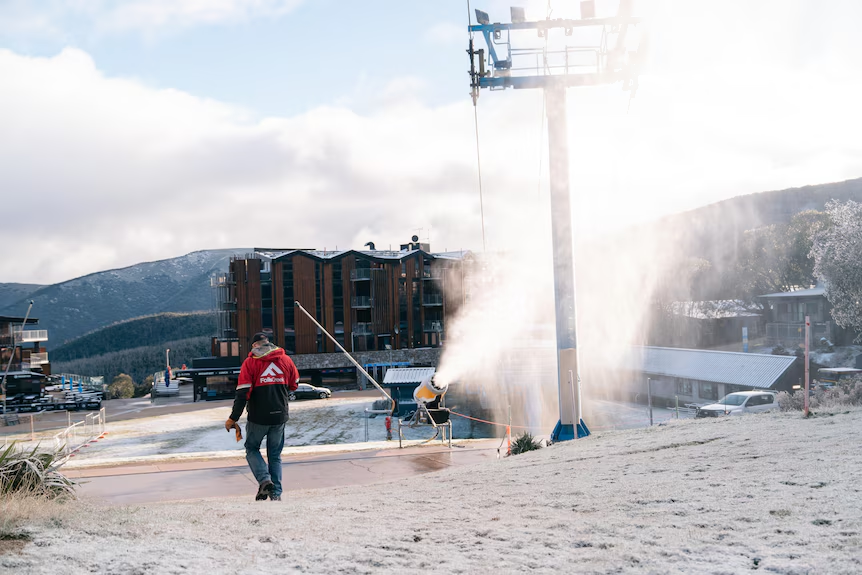
For ski resorts, the timing has been welcomed. The June long weekend traditionally marks the start of Australia’s ski season, and early cold helps lower ground temperatures before snowmaking begins in earnest. Resort operators at Falls Creek, Mt Buller, Mt Baw Baw and Mt Hotham said the fresh snow had lifted excitement after a warmer spell earlier in autumn.
But for drivers and farmers, the system brought risks. Alpine roads became icy and dangerous, with motorists urged to carry chains and drive slowly. In parts of Victoria, authorities also warned sheep graziers about the risk to livestock exposed to cold winds, showers and low temperatures.
Tasmania and the ACT were also caught in the freeze. kunanyi/Mt Wellington near Hobart dropped below zero, while Mt Ginini near Canberra recorded severe wind chill. Liawenee, one of Tasmania’s coldest settlements, also felt temperatures well below freezing once wind was factored in.
Forecasters expect the worst of the system to move through quickly. Snow showers are likely to continue across southern Victoria and Tasmania into Friday, but conditions north of the Murray River should clear faster. Temperatures are expected to recover gradually over the coming days, although frosty mornings may continue across inland areas.
The cold snap has delivered a dramatic early reminder that winter is close. Snow-covered cars near Perisher, white slopes at Mt Buller, icy roads near Mt Baw Baw and flakes falling around Jindabyne and Cooma have all made this one of the most memorable Australian weather events of the year so far.
Make Swikblog your go-to source on Google for reliable updates, smart insights, and daily trends.