A powerful rain system that drenched Australia’s arid interior with its heaviest falls in more than a decade is now sweeping toward the eastern seaboard, heightening flood concerns across Queensland and northern New South Wales.
After transforming normally dry desert waterways into fast-moving rivers, the weather band has shifted east, where forecasters warn of widespread heavy rain, severe thunderstorms and the potential for both flash and riverine flooding through the weekend.
Desert soaking revives dry riverbeds
Central Australia has just experienced one of its most significant rain events in 15 years. Parts of the Northern Territory and South Australia recorded up to 200 millimetres in isolated pockets — an extraordinary total for inland regions that often struggle to register meaningful rainfall in summer.
At Kati Thanda-Lake Eyre, one of the driest landscapes on the continent, some locations received roughly a year’s average rainfall in a matter of days. Creeks and rivers that had been bone-dry surged rapidly, in some cases rising as much as five metres within hours.
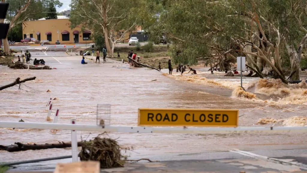
In Alice Springs, the usually parched Todd River began flowing last weekend after upstream gauges measured up to 191mm. The town’s airport logged 125mm in a single week — around three times the typical February average.
Satellite imagery from north-east South Australia shows waterways and lakes either damp or in active flow following the deluge, a rare sight in this part of the country.
Meteorologists attribute the outback soaking to an intrusion of exceptionally humid tropical air. That moisture plume has now contracted eastward, where it is forecast to linger for several days. Longer-range modelling also hints that another surge of tropical humidity could return to central Australia late next week, opening the door to further heavy rainfall before month’s end.
Eastern states brace for renewed downpours
While skies are clearing across parts of the interior, the same rain band is intensifying along the east coast. Northern NSW and south-east Queensland have already recorded substantial totals.
Doon Doon, inland from Byron Bay, received 241mm in the 24 hours to 9am Friday. Mullumbimby saw 182mm over the same period. Around the Gold Coast, more than 100mm fell in some districts — the heaviest rain there since Cyclone Alfred.
At times, rainfall rates near the Gold Coast reached 30mm per hour, increasing the risk of flash flooding, dangerous driving conditions and power disruptions.
Forecasters indicate that this concentrated pocket of heavy rain may shift north toward Brisbane and the Sunshine Coast, affecting millions across one of the country’s most densely populated corridors.
The Bureau of Meteorology has issued severe weather warnings, with more than 20 rivers from Queensland’s Central Highlands to NSW’s Northern Rivers under flood watch.
Weekend flood risk expands inland
Attention is now turning to inland Queensland, where thunderstorms are expected to become more widespread on Saturday and Sunday. Areas from the Northern Goldfields down through the Maranoa and Warrego districts face a heightened risk of severe storms capable of producing intense bursts of rain and flash flooding.
Meteorologists say this is not a brief or isolated event. Many regions could receive an additional 100 to 150mm over the coming days, creating an extensive stretch of wet weather from far north Queensland down to the south-east corner.
Beyond lightning-driven storms, heavy rain may also develop from persistent bands of moist, converging winds near the coastline. In such a humid environment, isolated totals well above 100mm remain possible in just a few hours.
Northern Territory still on alert
The earlier desert deluge left a dramatic mark in the Northern Territory. In Alice Springs, the Todd River turned into a torrent, prompting multiple rescues as floodwaters inundated low-lying roads and closed causeways.
Up to 100mm fell in parts of the catchment in just two hours, sending water surging through the usually dry riverbed. Emergency crews responded to stranded motorists, inundated homes and residents trapped by fast-moving water.
In one incident, a woman swept into floodwaters clung to a tree for 11 hours before being rescued.
Although water levels have since begun to fall, authorities have urged residents to remain cautious, noting that further rainfall could quickly reverse the reprieve.
Communities on high alert
Queensland has already been grappling with wild weather in its north following ex-Tropical Cyclone Koji, which left communities isolated and livestock losses widespread. The current system threatens to compound the strain, particularly in south-east Queensland where major transport routes and urban centres sit in flood-prone catchments.
Officials are warning that the primary impacts over the next several days will likely stem from flooding rather than wind damage. Both rapid-onset flash flooding and slower-developing river flooding are possible as catchments become saturated.
With humid tropical air lingering over the region and further bursts of rain forecast, the coming weekend is shaping up as a critical period for emergency services and communities across two states.
As central Australia dries out for now, attention remains firmly fixed on the east — where the rare desert deluge has set the stage for another round of potentially significant flooding.
Source: Additional reporting from The Canberra Times article Weekend flooding fear as heavy rain sweeps two states (published February 13, 2026): https://www.canberratimes.com.au/story/9174470/weekend-flooding-fear-as-heavy-rain-sweeps-two-states/
Make Swikblog your go-to source on Google for reliable updates, smart insights, and daily trends.


