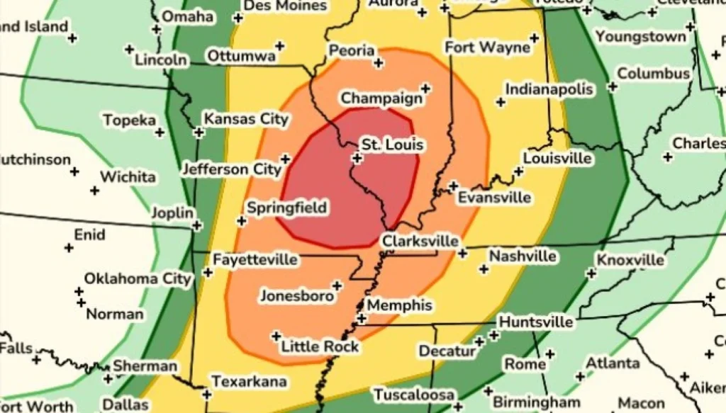
St. Louis entered Monday under one of its most serious severe weather outlooks of the spring, with forecasters placing the metro area under a Level 4 out of 5 storm risk as a fast-moving system threatened to bring damaging winds, large hail and tornadoes into the region.
The upgraded risk level immediately changed the rhythm of the day across eastern Missouri and parts of Illinois. School districts shortened class schedules, after-school programs were canceled, city services adjusted operations and several public venues closed early as officials tried to keep people off roads before storms arrived.
The greatest concern is the timing. Severe storms are expected to develop west of the metro in the afternoon before moving quickly toward the St. Louis area. The most active window is expected from about 4 p.m. to 9 p.m., a period that overlaps with the evening commute, after-school activities and the time when many families are usually heading home.
Why the Level 4 risk matters for St. Louis
A Level 4 severe weather risk, often described as a moderate risk by the Storm Prediction Center, is not issued for ordinary thunderstorms. It means forecasters see an elevated chance of widespread severe weather, including storms capable of producing significant damage.
For St. Louis, the main threats include powerful wind gusts, large hail and tornadoes. The tornado risk is especially important because some storms could rotate and strengthen quickly. While no forecast can predict the exact neighborhood that may be hit, the setup is serious enough that residents are being urged to prepare before storms reach the area.
Rolla is also included in the higher-risk zone, while Quincy is under a lower but still concerning Level 3 risk. That means severe weather is not limited to the city of St. Louis alone. Communities across the wider region may see rapidly changing conditions as storms track from west to east.
Damaging wind is one of the most likely hazards. Strong gusts can snap tree limbs, knock out power and make travel dangerous, especially on open roads and bridges. Large hail may also cause damage to cars, roofs and windows. If a tornado warning is issued, people should move immediately to a basement or interior room on the lowest level of a sturdy building.
Schools, offices and public venues change plans
The forecast prompted a long list of early dismissals across the St. Louis area. St. Louis Public Schools moved to a two-hour early release and canceled after-school activities. Parkway, Kirkwood, University City, Fox C-6, Lincoln County R-III, Affton and several other districts also changed schedules or canceled afternoon programs.
Many schools made the decision because the storm threat peaks later in the day. Early release gives buses, staff and families more time to get home before the strongest storms move through. Several districts also canceled sports, clubs, aftercare and evening events to avoid having students on campus during the most dangerous part of the forecast.
The closures went beyond schools. The St. Louis Zoo announced an early closure at 2 p.m. St. Louis City Hall also planned to close at 2 p.m., while essential operations continued. Some public meetings were postponed, including the Kirkwood Board of Education meeting, which was moved to Tuesday night.
Colleges and community organizations also adjusted schedules. St. Louis Community College planned to close at 1 p.m. and cancel evening classes, while Lewis and Clark Community College shifted to remote operations. Boys and Girls Clubs of Greater St. Louis closed for the day, and several community programs announced early shutdowns.
The scale of schedule changes shows how seriously local officials are treating the forecast. Severe weather during school dismissal or evening travel can create dangerous situations quickly, particularly if tornado warnings or destructive wind reports are issued while people are on the road.
Residents should avoid unnecessary travel during the late afternoon and evening if storms begin moving into the area. People who must drive should never stop under bridges during tornado warnings, and they should avoid flooded roads if heavy rain develops with the storms.
Families should also use the early part of the day to prepare. Charge phones, check flashlights, secure patio furniture, bring pets indoors and make sure everyone knows where to go if a warning is issued. Weather alerts from the National Weather Service St. Louis office can provide updated watches, warnings and local guidance as the system moves through.
The biggest danger with a day like this is waiting too long. Storms moving quickly from west to east can reduce reaction time, especially if warnings are issued close to home. Having a plan before 4 p.m. is safer than trying to decide what to do once sirens sound or phones begin sending alerts.
By Monday evening, the St. Louis region could face a mix of severe thunderstorms, damaging wind corridors, hail reports and possible tornado warnings. Not every community will see the same impact, but the Level 4 outlook means the environment is capable of producing dangerous weather. For residents, the message is simple: stay alert, stay close to shelter and take every warning seriously.
For continuing local updates, school closure information and weather developments, readers can follow our latest coverage on our weather updates page.
You may also like: Claire’s Closes 154 UK and Ireland Stores, 1,300 Jobs Lost
Make Swikblog your go-to source on Google for reliable updates, smart insights, and daily trends.