Written by Swikriti • Last updated: January 7, 2026 (AEDT)
Latest update (Victoria): Emergency “take shelter immediately” warnings have now been issued for the Longwood area, as multiple bushfires burn across Victoria under extreme heat and dangerous conditions. Authorities say the situation remains highly dynamic.
Longwood Fire: Emergency ‘Take Shelter’ Warning Issued
Emergency warnings have been issued for residents in and around Longwood, with authorities urging people to take shelter immediately as fire conditions worsen…
Authorities continue to urge residents to monitor official updates through VicEmergency.
A fast-moving bushfire burning near the NSW border has triggered urgent evacuation warnings across Victoria’s Upper Murray, with authorities telling residents in several small communities to leave immediately before conditions become too dangerous. The fire, burning west of Walwa near Wodonga, has already spread across a wide area of bushland and is moving through park terrain where shifting winds can quickly change the direction and intensity of the blaze.
Emergency services say the safest choice is to evacuate early, while roads remain passable and visibility is still manageable. The warning comes as Victoria faces harsh summer conditions, including extreme heat and the risk of wind changes that can push flames into new areas with little notice.
Where the fire is burning — and why the warning escalated
The Walwa fire has been burning in bushland near the border and has been reported moving within the Mt Lawson State Park toward the Bungil area. Fire behaviour has been complicated by changes in direction during the day—what starts as a slow edge fire can become a fast-moving front when the wind turns, sending embers ahead and increasing the risk to properties, fences, sheds, and vehicles.
Communities including Bungil, Granya, and Thologolong have been urged to evacuate immediately, with advice directing residents to leave along Murray River Road toward Wodonga. Authorities have warned that if people wait until the last minute, emergency crews may not be able to provide assistance once smoke thickens, trees fall, or road access becomes unsafe.
For the latest official warnings, evacuation advice, and maps, residents should monitor updates through VicEmergency, where alerts are updated as conditions shift.
Road closures and access: what’s been affected
Several roads in the area have been closed due to fire activity and safety concerns, including sections of Murray River Road and connecting routes. Some closures may remain open for local traffic leaving the area, but authorities can tighten restrictions quickly if flames approach the roadside or if smoke reduces visibility.
If you are in an advised evacuation area, plan the route first, leave early, and avoid shortcuts through forested roads. Fire conditions can change rapidly in gullies, along ridgelines, and near dense vegetation—especially in parkland.
Backburning efforts — and the “unburned fuel” risk
Fire crews have used overnight conditions to conduct backburning operations aimed at reducing fuel loads and slowing the fire’s spread. Backburning can be highly effective when temperatures drop and winds ease, but officials have flagged a key concern: a significant patch of unburned fuel between control lines and the active fire edge can still ignite and burn intensely during the day.
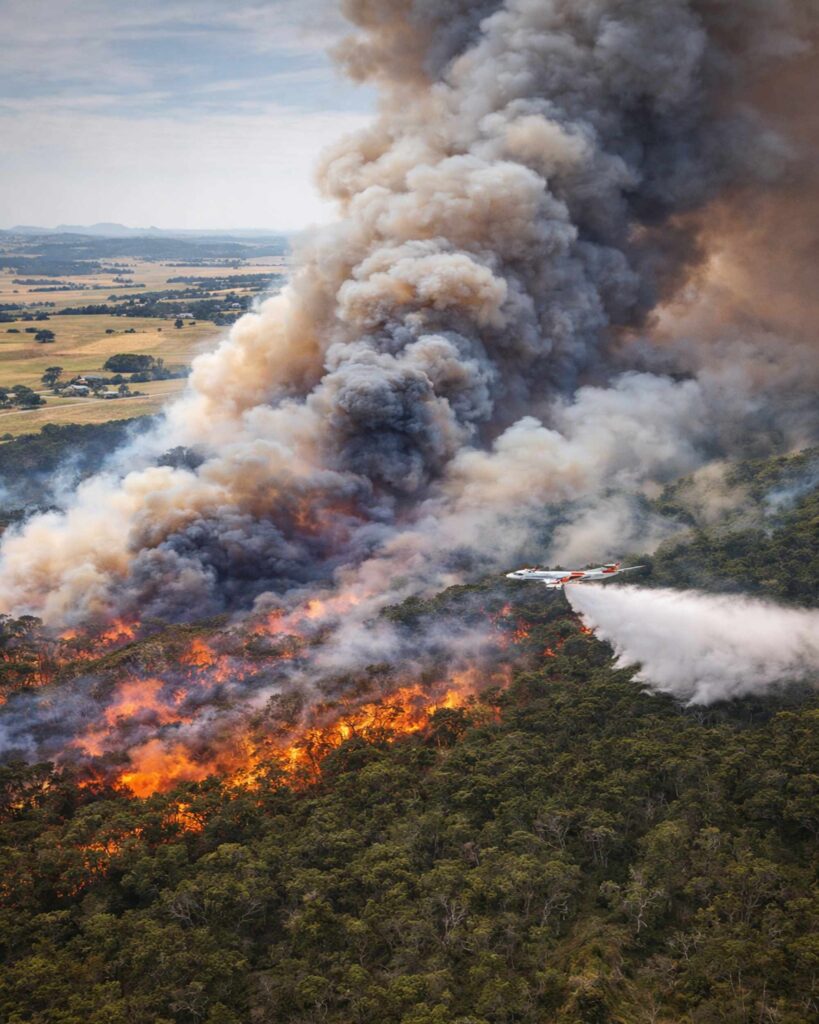
Air support, including waterbombing aircraft, has been assisting crews on the ground to suppress flare-ups and reduce fire intensity. Even with resources in place, authorities stress that communities in and around the warning zone should stay ready to move, particularly as hotter daytime conditions increase the chance of spotting and fast runs.
Extreme heat and a wind change could worsen conditions
The broader risk picture is being shaped by a stretch of elevated fire danger across Victoria, including intense heat and the possibility of strong winds later in the week. When a wind change arrives, it can swing the fire front into new areas, increasing the threat to communities that were previously “off to the side” of the fire’s path.
Total fire bans and high fire danger declarations have also been announced in multiple districts, reflecting the state’s broader risk. The Country Fire Authority’s advice and preparedness guidance can be found via the CFA.
Central-west grassfire warning downgraded, but vigilance remains
Separately, an emergency warning issued earlier for a grassfire burning near the Sunraysia Highway in Victoria’s central west was later downgraded to “watch and act.” While that change can be reassuring, it’s also a reminder that multiple incidents can unfold on the same day in extreme conditions—stretching resources and raising the importance of early decisions in any warning area.
What to do right now if you’re near Walwa or Upper Murray
- Leave early if advised. Evacuating before conditions deteriorate is safer than waiting for “confirmation.”
- Check live warnings frequently. Fire direction and severity can change within minutes.
- Pack essentials. Medications, phone chargers, IDs, water, and supplies for children and pets.
- Wear protective clothing. Long sleeves, sturdy shoes, and a mask if smoke is heavy.
- Tell someone your plan. Share your route and destination with friends or family.
If you’re outside the immediate warning zone but nearby, stay alert for smoke, ember fall, and changing weather. Keep vehicles fuelled, clear leaves from gutters, move outdoor furniture away from structures, and have hoses ready—while remembering that defending property is not safe in an emergency warning area.
How to stay informed without misinformation
In fast-moving bushfire situations, rumours spread quickly online. The most reliable updates come from emergency services, official warning platforms, and verified announcements. If you’re unsure whether your area is affected, don’t guess—use official maps and alerts, or contact local authorities.
For more safety explainers and breaking updates as conditions evolve, see the latest posts on Swikblog.
Note: This article summarizes the publicly reported emergency information shared by authorities and news coverage. Always follow official instructions and warnings in your area.
Make Swikblog your go-to source on Google for reliable updates, smart insights, and daily trends.