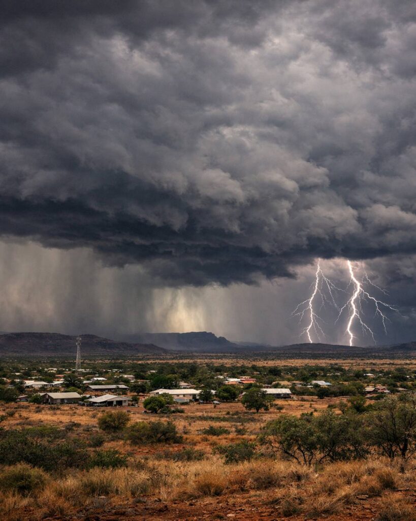
The Bureau of Meteorology (BOM) has confirmed the Wyndham weather radar will remain offline for at least the next few months after a lightning strike on Christmas Day triggered significant damage — an outage landing squarely in the Kimberley’s wet season, when radar visibility can matter most. For communities, travellers, pastoral stations and growers across the north-east Kimberley, it means fewer real-time clues about where storms are building, how fast they’re moving, and whether heavy rain is tracking toward roads, homesteads or town centres.
The Wyndham radar is one of the key tools people use to follow thunderstorms, intense downpours and fast-changing weather across the region. When it’s working, it offers an on-screen view that can help answer very practical questions: Is that storm headed this way? How long until it arrives? Is there another cell forming behind it? During the wet season, those answers can shape everything from outdoor work and travel timing to decisions about river crossings and moving livestock.
BOM has advised the radar is expected to be out of action for around three months, after the Christmas Day strike caused “considerable” damage. In plain terms: this is not a short, routine interruption. It’s a longer repair window that pushes into a time of year when the Kimberley typically sees frequent storm activity, humid heat and sudden bursts of heavy rainfall.
A radar outage does not mean the region is left without forecasts or warnings. BOM’s broader network still produces official forecasts, severe weather advice and warnings, and those remain the most important information to follow. But without local radar coverage, there’s a gap in the live “nowcasting” layer — the minute-by-minute tracking many people rely on when the sky turns dark and conditions escalate quickly.
What the outage changes for locals and travellers
In remote parts of northern WA, weather isn’t just background noise — it can be the difference between a normal day and a difficult one. Radar helps people anticipate the sharp edges of the wet season: sudden squalls, lightning storms, and rainfall intense enough to cut roads or swell creeks faster than expected. When the radar goes offline, people often lose a familiar early-warning habit: checking the loop, seeing what’s coming, and making a call.
That matters for anyone planning long drives between communities, for tour operators timing activities around storms, and for station owners weighing whether it’s safe to move people and equipment. It also matters for everyday household decisions — from outdoor work to school runs — when storms develop in the distance and arrive with little notice.
How to follow storms while the Wyndham radar is down
If you normally rely on the Wyndham radar loop, the best approach over the next few months is to layer information from multiple official sources rather than leaning on a single screen. Start with BOM’s current warnings and forecasts for WA, then add satellite imagery and nearby radar views where available.
- Check official WA warnings and forecasts: Use BOM’s WA hub for current warnings, forecast districts and links to radar/satellite products. BOM Western Australia
- Use satellite imagery to track storm build-up: Satellite won’t replace radar, but it helps you see cloud growth, storm lines and movement across the broader region. BOM Satellite Images (or the hi-res viewer: Satellite Viewer)
- Look at nearby radar coverage where relevant: Depending on your location, surrounding radars may still show parts of the weather picture. For example: Broome radar and Darwin (Berrimah) radar.
The most important habit: when BOM issues a warning, treat it as your primary signal — even if the sky looks calm where you are. Wet-season storms can be highly localised, and conditions can change quickly across short distances.
Why a single radar can matter so much in the Kimberley
In large, sparsely populated areas, there are fewer “eyes on the ground” and fewer layers of local infrastructure. Radar becomes a shared tool for situational awareness — not just for meteorologists, but for the people who live and work under the weather. During the wet season, when thunderstorms can form rapidly and bring intense rain, a working radar can help people make better-timed decisions and avoid unnecessary risk.
The disruption is also a reminder of how exposed critical services can be to extreme weather. Lightning strikes, fires and storm damage are part of the environment in northern Australia — and when they hit a key piece of monitoring equipment, the flow-on effects can be felt well beyond the radar site itself.
BOM has not suggested forecasts or warnings will stop — they won’t. But for many Kimberley residents, the practical loss is the ability to “read” the weather in real time the way they’re used to, especially when storms are nearby and decisions are time-sensitive.
For ongoing updates and official products, keep an eye on BOM’s WA page and satellite imagery tools. If you’re travelling in the region during the wet season, consider building extra buffer time into plans, and check warnings before setting out — particularly if your route involves remote roads, river crossings or areas prone to sudden flooding.
Read more reporting: ABC News (Kimberley) on the Wyndham radar outage • The Kimberley Echo report
Make Swikblog your go-to source on Google for reliable updates, smart insights, and daily trends.