Bitter Cold and 30 cm of Snow: What Toronto Residents Should Expect
Toronto is heading into a tough winter stretch: deep cold that bites at exposed skin, followed by a snowstorm that could pile up quickly, cut visibility and slow the city to a crawl. Here’s what forecasters are flagging — and the practical steps residents can take before the first heavy flakes arrive.
At a glance
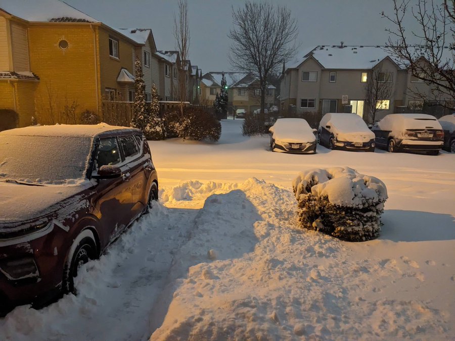
Snow: Forecasts point to roughly 15–30 cm across the Toronto area, with locally higher totals possible where bands set up.
Timing: Snow may begin early Sunday, intensify through the afternoon and evening, and linger into Sunday night or early Monday.
Main risks: Rapid accumulation, blowing snow, near-zero visibility at times, and hazardous travel.
The biggest headline is the number: up to 30 cm is enough to change how a city moves. It’s not just the depth — it’s the pace. When snow falls hard for hours, plows and salt trucks can struggle to keep up, especially on side streets where buildup happens fast. Add gusty winds and the same snowfall can feel heavier because it drifts, hides lane markings and reduces what drivers can see ahead.
Toronto’s challenge this weekend is the combination of systems. Bitter cold has already set the tone, and that matters because colder air can produce lighter, fluffier snow that stacks quickly. It can look deceptively manageable until you realize it’s accumulating faster than expected and blowing into deep ridges along curbs, driveways and intersections.
Forecasters are also watching for lake enhancement off Lake Ontario. When winds and temperatures align, narrow but intense snow bands can form and sit over the same neighborhoods for hours. That’s how one part of the city can end up with a dramatic total while another sees a more modest accumulation. In these setups, visibility can swing from fine to near whiteout within minutes.
The timing is another reason the warning is getting attention. Snow arriving early and intensifying through the day increases the chance that errands, shift work, and weekend travel plans collide with worsening road conditions. If the heaviest snowfall overlaps with the evening period, that’s when traffic volumes can amplify problems: more vehicles, slower speeds, more minor collisions, and longer waits for tow trucks.
The cold itself is not an afterthought. Severe wind chills can raise the risk of frostbite quickly, especially for people who have to spend time outdoors — commuters waiting for transit, delivery workers, or anyone clearing snow multiple times. If you’re shoveling, it’s the mix of exertion and icy air that catches people out: take breaks, hydrate, and avoid pushing through chest tightness or dizziness.
What should residents do now? The essentials are simple, but they work best when done before the storm is at your doorstep.
- Plan your travel window: If you can shift errands earlier, do it. If you must drive, top up fuel, charge your phone, and allow extra time.
- Prep your sidewalk and entry: If you have salt or grit, place it where you’ll need it. Keep a shovel accessible, not buried behind snow-prone doors.
- Protect pipes and property: Cold snaps can stress older plumbing. Know where your shut-off valve is and keep a slow drip if your home is prone to freezing.
- Check on people and pets: Older neighbors, anyone with mobility issues, and outdoor animals are most vulnerable when wind chills plunge.
- Expect delays: Transit slowdowns, longer commutes, and messy sidewalks are common after fast, heavy snowfall.
For anyone tracking official wording and updates, the most reliable place to monitor changing warnings and timing is the latest forecast for Toronto. Environment Canada’s Toronto forecast and alerts is the best reference point as conditions evolve.
The key thing to remember is that storms like this are less about a single number and more about how the day unfolds: bursts of intense snow, shifting visibility, and slippery roads that look merely wet until they aren’t. If Toronto ends up with the higher end of the range — especially with lake-effect enhancement — the normal routine can get disrupted quickly.
We’ll continue tracking updates on Swikblog weather updates as the storm approaches, including timing changes, travel impacts and what residents can expect once crews begin clearing the city.
Make Swikblog your go-to source on Google for reliable updates, smart insights, and daily trends.