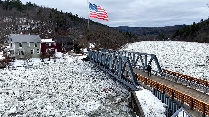
Rising temperatures across parts of the Northeast are accelerating snowmelt and triggering concerns about potential flooding as rivers begin to break apart after a long winter freeze. In Enosburg Falls, Vermont, dramatic footage showing large chunks of ice rapidly moving down the Missisquoi River is highlighting the growing risks tied to seasonal river breakup.
The movement of heavy ice sheets is a typical sign that rivers are transitioning into spring flow conditions. But when combined with rainfall and melting snowpack, the situation can increase the likelihood of flooding in communities located along vulnerable waterways.
Ice Breakup Signals Heightened Flood Risk
During late winter and early spring, river ice often fractures as temperatures climb above freezing. The broken slabs of ice travel downstream where they may accumulate at narrow bends, bridges, or shallow sections of rivers. This process can form what is known as an ice jam — a natural blockage that restricts water flow and forces water levels to rise rapidly upstream.
When ice jams occur, flooding can develop quickly and often without the gradual buildup typically seen in rainfall-driven flood events. As a result, emergency managers and meteorologists closely monitor rivers during thaw periods when ice movement becomes visible.
Video captured in Enosburg Falls shows the Missisquoi River carrying large ice fragments at high speed, illustrating how quickly winter ice can begin moving once conditions shift. The river flows north through Vermont and into Canada’s Lake Champlain watershed, making it an important system to monitor during spring runoff.
Rainfall and Snowmelt Combine to Raise River Levels
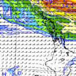
The broader weather pattern is adding additional pressure to regional waterways. Forecasters expect rainfall totals between one and one and a half inches across portions of northern New York and Vermont, while warmer air temperatures continue to melt remaining snowpack.
Parts of northern New York still contain more than a foot of accumulated snow in certain areas, particularly within the Black River basin. When heavy snow begins melting while rain is falling, runoff flows directly into rivers and tributaries, increasing water levels across the region.
Hydrologists warn that the combination of rainfall and rapid snowmelt can accelerate river flow and increase the likelihood of flooding in low-lying areas, particularly near creeks, streams and drainage systems.
Flood Watch Issued Across Northern New York
The National Weather Service has issued a flood watch for Jefferson and Lewis counties in northern New York, warning that rivers and streams could rise significantly as precipitation and snowmelt feed local waterways. Areas along the Black River, Moose River, Independence River and Beaver River are among those being monitored closely.
Officials say ice jams remain a concern in places where river ice has not fully broken apart. If moving ice becomes trapped along a river channel, water can quickly back up and overflow into surrounding areas.
Residents can track river levels and hydrologic data through the NOAA National Water Prediction Service, which provides real-time monitoring of river gauges across the United States.
Communities Urged to Monitor River Conditions
Local authorities are encouraging residents living near rivers and streams to remain alert as weather conditions evolve. Flood risks during spring thaw periods can change rapidly depending on temperature shifts, rainfall intensity and how quickly snowpack melts.
Emergency officials advise residents to watch for early signs of flooding, including water rising near riverbanks, ice accumulation near bridges and rapidly increasing stream flows. Roads near rivers may also become vulnerable if water levels climb quickly.
Flood preparedness guidance and safety information is available from the National Weather Service flood safety center, which provides recommendations for responding to rising water and protecting property during flood events.
Seasonal River Breakup Underway Across the Northeast
The ice movement observed on the Missisquoi River reflects a broader seasonal shift now underway across northern parts of the United States. As winter conditions give way to spring, rivers across the Northeast often experience periods of rapid change as frozen channels reopen.
While most ice breakup events pass without major impacts, periods of heavy rain and rapid snowmelt can increase the risk of flooding and ice jam formation. Meteorologists say the coming days will be important in determining how regional rivers respond to the warming trend and additional precipitation.
For communities along the Missisquoi River and other waterways across New York and Vermont, the arrival of spring runoff means closely watching water levels as winter ice finally gives way to the new season.
You May Also Like
Make Swikblog your go-to source on Google for reliable updates, smart insights, and daily trends.