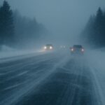
Canada is bracing for an unusually early blast of winter as a major disruption in the polar vortex sends Arctic air diving south far ahead of schedule. Forecasters warn that a rare atmospheric shift could trigger colder temperatures, early snowfall and sharper winter storms — with ripple effects likely for the northern United States and even parts of Europe.
⚠️ Weather Alert: Early Arctic Blast Incoming
Canada is entering a high-impact cold phase as a weakened polar vortex drives Arctic air southwards. Expect sharp temperature drops, icy winds and periods of snow through the next 5–7 days.
- Prairies: Wind chills falling to –15°C to –20°C, risk of freezing roads.
- Alberta–Manitoba corridor: Light snow early week, heavier bands possible late next week.
- Ontario & Quebec: Colder-than-normal temperatures by mid-week.
- Northern U.S. states: Early freeze alerts for ND, MN, MT; patchy snow may affect early morning travel.
Travellers, commuters and households should monitor updated snowfall alerts and wind-chill warnings as the pattern evolves.
The phenomenon is linked to an early-season Sudden Stratospheric Warming (SSW), a rare event that weakens the polar vortex and allows frozen Arctic air to spill outward. Meteorologists say this is one of the earliest disruptions recorded in decades, raising the likelihood of a harsher start to winter than usual.
According to Global News, provinces including Saskatchewan and Manitoba are facing “the strongest blast of Arctic air so far,” with wind chills dropping towards –20°C and conditions turning “dangerously cold” in days. Weather analysts suggest similar shifts may push colder-than-normal temperatures into northern U.S. states as early as next week.
Scientists tracking the disruption note that early vortex splits often lead to more frequent snow events, icy road conditions, and increased strain on heating systems. A deeper analysis published by Severe Weather Europe highlights the potential for extended cold spells through December.
What This Means for Readers
- Earlier snow & travel delays: Expect risks of flight disruptions and highway slowdowns in colder regions.
- Higher heating demand: Energy costs may rise sooner than expected as temperatures plunge.
- Weather alerts likely: Northern U.S. states should watch for enhanced snow and freeze warnings.
Forecast for the Coming Days
Weather models show that the next week will bring a sharper, more persistent drop in temperatures across western and central Canada as the weakened polar vortex allows deeper Arctic air to spill south. Meteorologists expect daytime highs to stay below freezing in Alberta, Saskatchewan and Manitoba, with nighttime wind chills reaching –15°C to –20°C through the early part of the week.
The Weather Network is also tracking a sequence of “reinforcing cold waves” that could trigger on-and-off light snowfall across the Prairies. A more organised system is being monitored for late next week, which could bring heavier snow bands to parts of central and eastern Canada.
As the cold mass pushes further east, Northern Ontario and Quebec may see below-normal temperatures by mid-week, with slick roads during early morning hours. The same atmospheric pattern may extend into the northern United States, with North Dakota, Minnesota and Montana likely to experience early-season freeze risks and patchy snow, potentially disrupting early-week travel.
For those tracking other fast-moving global stories, you can also read our related coverage: Swikblog trending analysis and Ethiopia volcano update.
Make Swikblog your go-to source on Google for reliable updates, smart insights, and daily trends.