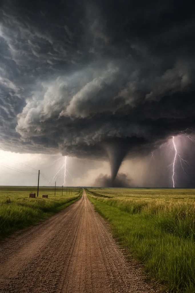
A powerful spring storm system is putting millions of Americans on alert as meteorologists warn of a severe weather outbreak stretching from Texas to Missouri. The developing system could unleash strong tornadoes, destructive hail and damaging winds across several states over the next two days, marking one of the first major severe weather threats of the 2026 spring season.
Forecasters say atmospheric conditions across the central United States are aligning for a dangerous setup capable of producing EF2-strength tornadoes or stronger. Alongside the tornado threat, storms could also generate giant hail larger than golf balls, powerful wind gusts and heavy rainfall capable of causing flash flooding in vulnerable areas.
Storm System Targets the Central United States
The primary danger zone currently stretches from western Texas through Oklahoma, Kansas and into Missouri. Meteorologists say a boundary known as a dryline is expected to trigger thunderstorms Thursday afternoon and evening, particularly across western portions of Texas and Oklahoma.
When warm, humid air from the Gulf of Mexico collides with cooler air moving across the Plains, the atmosphere becomes highly unstable. That instability allows thunderstorms to rapidly intensify and evolve into rotating supercell storms capable of producing tornadoes.
Several cities could find themselves near the center of the storm threat, including Lubbock, Amarillo, Wichita Falls and Oklahoma City. Some storms may continue moving eastward into the evening hours, bringing severe weather risks closer to more populated areas.
Friday Could Bring a Larger Tornado Outbreak
While Thursday’s storms may initiate the event, forecasters believe Friday could bring a much broader and potentially more dangerous outbreak. The severe weather risk is expected to expand across a large swath of the central United States as atmospheric energy builds.
Areas from northern Texas through Oklahoma and Kansas into Missouri are likely to experience the highest risk. Major metropolitan areas including Dallas, Austin, Tulsa, Kansas City and Des Moines could all face severe thunderstorms as the system intensifies.
Some storms could also push farther north into parts of the Midwest, potentially bringing strong thunderstorms as far as Chicago and surrounding areas. Meteorologists say the combination of strong wind shear, deep moisture and an advancing weather system could allow multiple supercells to develop simultaneously.
According to the NOAA Storm Prediction Center, these types of environments often support the development of long-lived rotating storms capable of producing significant tornadoes.
Giant Hail and Destructive Winds Also Possible
Tornadoes are not the only concern with this outbreak. Severe thunderstorms may also produce very large hail capable of damaging vehicles, roofs and crops. In some areas, hailstones could exceed the size of golf balls.
Additionally, strong thunderstorm wind gusts may reach 60 to 75 mph, powerful enough to knock down trees and power lines. These straight-line winds can sometimes cause damage similar to weaker tornadoes.
With multiple storms expected to form along the same weather boundary, forecasters say communities could experience repeated rounds of severe thunderstorms through Friday evening.
Heavy Rain Could Trigger Flash Flooding
Alongside the tornado and hail threats, heavy rainfall could also become a serious concern. Meteorologists say some areas across the Southern Plains and Mississippi Valley could receive more than three inches of rain over several days.
The highest flash flooding risk may develop across parts of eastern Oklahoma, western Arkansas and southwest Missouri. Mountainous terrain in regions like the Ozark and Ouachita Mountains can make flooding more dangerous because water can quickly funnel into valleys and streams.
Repeated thunderstorms moving across the same locations could significantly increase the flooding risk into early next week.
Weather Pattern Behind the Outbreak
Meteorologists say the current setup is driven by a stalled weather front stretching across the central United States. South of that boundary, warm moisture from the Gulf is surging northward while colder air remains in the upper atmosphere.
This combination creates strong instability, which allows thunderstorms to grow rapidly and organize into severe storm clusters. Wind patterns higher in the atmosphere are also favorable for rotating storms, which increases the likelihood of tornado formation.
Some of the unusual weather patterns affecting the United States this winter have also been influenced by La Niña conditions in the Pacific Ocean. During La Niña winters, the jet stream often shifts northward, leaving southern regions warmer and drier than normal while storm systems track across the Plains and Midwest.
While the incoming storms could bring dangerous weather, they may also deliver much-needed rainfall to drought-affected regions across the southern United States.
Residents Urged to Monitor Weather Alerts
Emergency officials and meteorologists are urging residents across the affected states to stay alert as the storm system develops. Severe weather conditions can evolve rapidly, and warnings may be issued with little notice once storms begin forming.
Experts recommend having multiple ways to receive alerts, including weather apps and local emergency notifications. People living in high-risk areas should also identify safe shelter locations such as basements or interior rooms away from windows.
With spring severe weather season just beginning, this outbreak could be an early reminder of how quickly powerful storms can develop across the central United States.
Make Swikblog your go-to source on Google for reliable updates, smart insights, and daily trends.