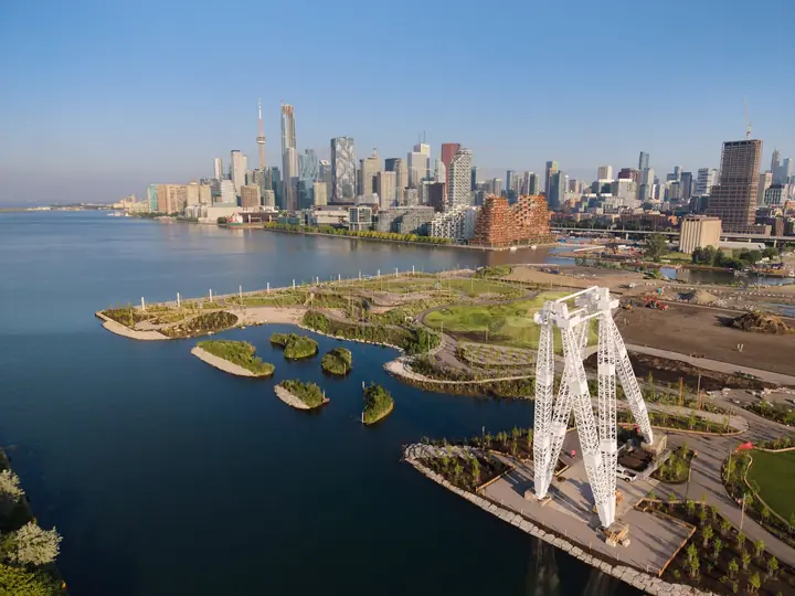

Toronto’s largest new park in a generation has expanded again, adding 10 acres of waterfront space with panoramic skyline views, public art, paddling access and a restored industrial landmark.
The western phase of Biidaasige Park opened on Saturday, July 25, 2026, on Ookwemin Minising in the Port Lands. It brings the park’s developed area to more than 60 acres and creates a new destination for families, cyclists, paddlers, photographers and eventgoers.
The expansion is also part of a much larger transformation. Former industrial land has been converted into public space while the rerouted Don River provides flood protection and prepares the surrounding area for future housing.
What opened in the 10-acre expansion?
The western section extends from the Cherry Street South Bridge toward the Inner Harbour. Its centrepiece is an elevated promontory with views of downtown Toronto, the CN Tower, Toronto Islands, Lake Ontario and the naturalized Don River.
A sloping event lawn can accommodate approximately 3,000 people for performances and community gatherings. When no event is scheduled, it remains open for picnics, sunbathing and harbour watching.
The expansion strengthens Toronto’s network of public lakeside spaces. During busy dates such as the Toronto Victoria Day fireworks at Ashbridges Bay Park, waterfront destinations can attract large crowds, making transit and early travel planning important.
Promenade, paddling and public art
The Water’s Edge Promenade follows the former Marine Terminal 35 site. Lighting columns and preserved foundation lines mark where the industrial building once stood, while the path offers unobstructed views across the Inner Harbour.
Canoe Cove provides a sheltered landing for canoes, kayaks and stand-up paddleboards. Paddlers should be prepared for wind, waves and commercial vessel traffic. There is no on-site watercraft storage, and construction may restrict access to parts of the Keating Channel and Lower Don River.
The western section extends the Lassonde Art Trail with permanent and temporary installations. Works include Alexa Kumiko Hatanaka’s against the wind, with the wind and Hank Willis Thomas’s Savario and Daisy (Navel). An installation by Kent Monkman is expected in September 2026.
A sheltered fire pit designed by Solomon King incorporates footprints into its stonework. Indigenous planting areas include sweet grass, sacred tobacco, white sagebrush, staghorn sumac and black cherry.
Why the Atlas Crane was preserved
The approximately 300-tonne Atlas Crane is the expansion’s most visible industrial landmark. Installed in 1961, it once loaded and unloaded cargo at Marine Terminal 35, including old TTC streetcars being shipped overseas.
The designated heritage structure has been restored and will be illuminated at night. It is not a climbing attraction, and protective measures have been installed around its base.
Does Biidaasige Park have a zipline?
Yes. Cableway Canyon has two zipline-style cableways measuring 20 metres and 40 metres. However, they are located in the section that opened in July 2025, not inside the new western expansion.
Other family attractions include the Snowy Owl Theatre, Badlands Scramble water-play area, swings, a mock beaver dam, a raccoon climbing structure and wooden dodem animal sculptures developed with Indigenous cultural guidance.
Parking, TTC and water-shuttle access
The closest major intersection is Cherry Street and Commissioners Street. The western entrance is near 238 Cherry Street.
Parking is limited. A temporary lot at 11 Munition Street has approximately 120 spaces, while restricted on-street spaces may be available on Old Cherry, Villiers and Munition streets.
TTC route 114 Queen’s Quay East stops near Cherry and Commissioners streets. Route 72D Pape stops near Saulter and Commissioners. The park also connects with the Martin Goodman and Lower Don trails, with Bike Share stations and bicycle parking available.
Ride-share passengers should use 11 Munition Street because pickups and drop-offs are prohibited on Commissioners Street.
The seasonal East-West Water Shuttle serves Ookwemin Minising near 242 Cherry Street. Vessels carry approximately 12 passengers, so advance booking and a backup travel plan are recommended.
Wheel-Trans users have designated drop-off points near Old Fire Hall 30 and the western entrance. Current transportation and accessibility details are available through the City of Toronto’s Biidaasige Park travel guide.
Read More:
Washrooms, food and dog rules
Temporary washrooms are available near the western entrance. A proposed pavilion could eventually provide permanent washrooms, a café and programming space, but funding and a construction schedule have not been confirmed.
Food services are limited, and shade remains sparse while new trees mature. Visitors should carry water, sunscreen and food for longer stays. Swimming or diving from the promenade’s dock wall is prohibited.
Two off-leash dog areas include seating, fountains, waste bins and accessible gates. Dogs must remain leashed elsewhere to protect wetlands and planted habitats.
People interested in another nature-focused city outing can review visitor advice for the High Park cherry blossom season, including guidance about crowds, transit and protecting sensitive landscapes.
How the project transformed the Port Lands
Biidaasige Park is part of the $1.4-billion Port Lands Flood Protection project funded by Canada, Ontario and Toronto. It created a new one-kilometre naturalized mouth for the Don River and protects 174 hectares of the eastern waterfront from flooding.
The landscape contains more than 5,000 trees, 77,000 shrubs and two million herbaceous plants. Biidaasige means “sunlight shining toward us,” while Ookwemin Minising means “place of the black cherry trees.”
The 98-acre island is eventually expected to accommodate more than 15,000 residents, at least 9,000 homes and nearly 3,000 jobs, along with additional parks and community facilities.

Make Swikblog your go-to source on Google for reliable updates, smart insights, and daily trends.