A powerful late-season Pacific storm is lining up to hit parts of the Western United States with dangerous force, bringing a heavy snow warning that could bury mountain corridors under as much as 20 inches of snow while wind gusts near 50 mph raise the risk of whiteout conditions, black ice, and sudden highway shutdowns.
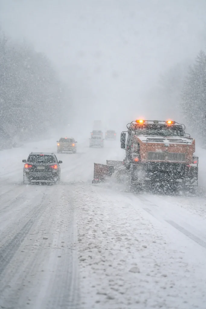
The storm is shaping up as a major travel hazard across several elevated routes and exposed highway stretches in the Intermountain West. Forecast details point to the greatest disruption over mountain passes and higher terrain, where snowfall rates and blowing snow could quickly turn already difficult driving into a serious safety concern. For motorists heading toward the Cascades, the Wasatch Back, Nevada’s mountain routes, or areas surrounding the greater Lake Tahoe corridor, the timing could hardly be worse.
This system arrives at a moment when parts of the region are still hoping for late-season snowfall to improve water and snowpack conditions, especially in states such as Utah. The latest outlook from Utah weather observers suggested that while recent storms have delivered some help, the broader snow-content picture remains weak across several mountain ranges. Seasonal patterns have also continued to lean warmer and drier overall, making each incoming storm more important than usual as winter begins to transition toward spring.
Main threat: Up to 20 inches of heavy snow, wind gusts of 40 to 50 mph, rapidly falling visibility, chain restrictions, and the potential for major delays or temporary highway closures across key Western mountain routes.
The most immediate risk for travelers is not just the amount of snowfall, but the combination of snow and wind. Gusts in the 40 to 50 mph range can push loose snow across road surfaces and create abrupt whiteout conditions, especially in exposed corridors where crosswinds hit hardest. High-profile vehicles such as delivery vans, pickups with trailers, buses, and semis are likely to face the greatest danger. Visibility can collapse in seconds, leaving almost no reaction time when traffic slows or road conditions suddenly worsen.
Another major concern is the likelihood of chain controls and emergency restrictions. Once heavy accumulation starts building on steep grades and major passes, transportation agencies can move quickly to limit traffic or require traction devices. In the hardest-hit areas, full closures are possible if road crews struggle to keep lanes open. Even where roads remain technically open, stop-and-go traffic, spinouts, and weather-related crashes can produce long backups and sharply extend travel times.
Road surfaces may become even more hazardous as temperatures fall behind the storm. Wet pavement can freeze underneath fresh snow, producing slick layers of black ice that are difficult to spot, especially after sunset or during early morning travel. That risk is particularly high in elevated terrain, shaded canyon stretches, bridge decks, and lesser-traveled routes where surface treatment may lag behind changing conditions.
Utah’s short-range outlook also points to cooler conditions lingering into the weekend before precipitation begins to taper off. Forecasters have indicated that the midweek system is expected to weaken as it heads toward the weekend, but that does not eliminate the near-term travel danger. Even a weakening storm can cause severe disruption when snow falls over major passes and combines with strong wind. Into next week, temperatures are expected to rebound, with northern valleys rising into the 50s and 60s and southern Utah climbing back into the mid-70s, though some moisture may still brush northern mountain areas.
That warming trend may improve lower-elevation driving conditions later, but it also underscores how narrow the current storm window is. Travelers attempting to cross mountain terrain before the pattern shifts could be dealing with the most dangerous setup of the week. For anyone with flexible plans, delaying travel may be the most practical choice.
Drivers who absolutely must head into the affected areas should prepare for true winter operating conditions. That means winter-rated tires, a full tank of fuel, charged mobile devices, extra warm layers, food and water, and a vehicle emergency kit stocked for extended delays. Real-time highway conditions and official storm alerts can shift quickly, so checking updates from the National Weather Service before departure is essential.
In many cases, the safest route may be the one that avoids the highest elevations entirely. Mountain travel during a storm of this magnitude can deteriorate much faster than valley forecasts suggest. A drive that starts with wet pavement and light snowfall can turn into a near standstill once elevation increases, especially if snowfall rates intensify and plows are unable to keep pace.
The bigger picture is simple: this is not just another routine winter weather event. The mix of heavy snow, strong winds, falling temperatures, and vulnerable mountain infrastructure creates the potential for fast-moving travel chaos across some of the West’s most important highway links. Anyone planning road travel through the affected zones over the next couple of days should be ready for delays, restrictions, and rapidly changing conditions that can turn hazardous without much warning.
For Western states still waiting on meaningful late-season snow, the storm may offer some much-needed accumulation in the high country. But for drivers, freight operators, and weekend travelers, the system is likely to be remembered less for relief and more for the disruption it brings to already difficult winter routes.
Make Swikblog your go-to source on Google for reliable updates, smart insights, and daily trends.